1960s Maps of Kathio Township, Minnesota
Explore 4 historic maps of Kathio Township from the 1960s. These maps offer a rare glimpse into what life looked like during the 1960s — showing old roads, neighborhoods, homes, and landmarks that have changed or disappeared over time.
Whether you're researching your family's past, planning a metal detecting trip, or studying how Kathio Township's landscape evolved across the 1960s, these high-resolution maps are a powerful tool for exploring the history of this region.
- Focus on a specific era: All maps on this page are from the 1960s, giving you a focused view of this time period.
- See what’s changed: Compare century-old streets, trails, and buildings to today's modern landscape using overlays and satellite layers.
- Research with precision: Use these maps for genealogy, historical research, land use analysis, or educational projects.
- View, download, or print: Maps are fully viewable online in high resolution, and can be downloaded or printed for your own records.
Start exploring Kathio Township's history through authentic maps from the 1960s. This is your window into the past.
Kathio Township, MN maps
(4)- 1968 Map of Onamia NW, 1970 Print
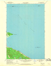 1968 Onamia NW1970 Print · USGSThe southwestern reaches of Mille Lacs Lake are captured here in the late sixties, showcasing a landscape defined by conservation and recreation. Researchers can trace the early boundaries of Mille Lacs Kathio State Park and locate offshore landmarks like Spirit Island.2 unique versions available
 - 1968 Map of Onamia, 1970 Print
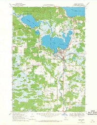 1968 Onamia1970 Print · USGSThe southern shore of Mille Lacs Lake comes into focus during the late 1960s, showing the intersection of industry, faith, and conservation. Genealogists and local historians can trace the foundations of Onamia through the Crosier Seminary, Holy Cross Church, and several local cemeteries.2 unique versions available
 - 1968 Map of Vineland, 1970 Print
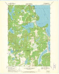 1968 Vineland1970 Print · USGSThe southwestern shores of Mille Lacs Lake are captured here in the late sixties, centered on the settlement of Vineland. Researchers can trace local history through the Alliance Mission, Lakewood Cem, and the boundaries of Mille Lacs Kathio State Park.
 - 1968 Map of Hillman SE, 1970 Print
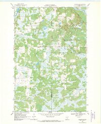 1968 Hillman SE1970 Print · USGSThe Morrison and Mille Lacs county line in the late sixties reveals a landscape of dense wetlands and state timberlands. Genealogists and historians can trace the Soo Line rail corridor through Johnsdale or locate landmarks like the Gravel Pit and Radio Tower.2 unique versions available
End of results
Showing maps 1-4 of 4
Top cities near Kathio Township
- Onamia historical maps
- Wahkon historical maps
- Wealthwood historical maps
- Garrison historical maps
- Hillman historical maps
Frequently asked questions
- What are the different types of historical maps available for Kathio Township?
- What is the oldest map of Kathio Township?
- Where can I purchase historical maps of Kathio Township for my home or office?
- Where can I download high-res historical maps of Kathio Township?
- Are there historical topographic maps available for Kathio Township?
- Is there historical aerial imagery available for Kathio Township?
- Where are historical maps of Kathio Township sourced from?