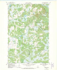
1968 Map of Hillman SE
USGS Topo · Published 1970About this map
Johnsdale serves as a small focal point in this 1960s landscape, situated along the Soo Line tracks that cut through the southeastern corner of the quadrangle. This area on the border of Morrison and Mille Lacs counties is defined by a heavy concentration of marshland and lakes, particularly in the townships of Richardson, Leigh, and Bradbury. The northern reaches of the map include the protected wilderness of Mille Lacs Kathio State Park and the Rum River State Forest, where the Rum River winds through the timberland. Smaller waterways like Skunk R, flowing from Skunk Lake, and the North Fork Bradbury Brook provide drainage for the numerous wetlands. The map also records industrial markers of the time, such as a Gravel Pit near the railroad and a prominent Radio Tower in the Bradbury area.
Find a feature on this map
15 named features on this map. Tap any name to fly to it.
Don’t see what you’re looking for? This feature index may not catch every label — zoom into the map to look around manually.
Map Details
Editions of this 1968 Hillman SE Map
2 editions found
Other maps of this area

1953 · Duluth
USGS Topo · 1:250,000

1953 · Stillwater
USGS Topo · 1:250,000

1955 · Stillwater
USGS Topo · 1:250,000

1958 · Stillwater
USGS Topo · 1:250,000

1958 · Duluth
USGS Topo · 1:250,000

1965 · Stillwater
USGS Topo · 1:250,000

1968 · Onamia NW
USGS Topo · 1:24,000

1968 · Ramey NE
USGS Topo · 1:24,000

1968 · Onamia
USGS Topo · 1:24,000
1968 · Platte Lake
USGS Topo · 1:24,000