1980s Maps of Murray County, Minnesota
Explore 4 historic maps of Murray County from the 1980s. These maps offer a rare glimpse into what life looked like during the 1980s — showing old roads, neighborhoods, homes, and landmarks that have changed or disappeared over time.
Whether you're researching your family's past, planning a metal detecting trip, or studying how Murray County's landscape evolved across the 1980s, these high-resolution maps are a powerful tool for exploring the history of this region.
- Focus on a specific era: All maps on this page are from the 1980s, giving you a focused view of this time period.
- See what’s changed: Compare century-old streets, trails, and buildings to today's modern landscape using overlays and satellite layers.
- Research with precision: Use these maps for genealogy, historical research, land use analysis, or educational projects.
- View, download, or print: Maps are fully viewable online in high resolution, and can be downloaded or printed for your own records.
Start exploring Murray County's history through authentic maps from the 1980s. This is your window into the past.
Murray County, MN maps
(4)- 1985 Map of Sioux Falls
 1985 Sioux Falls1985 Print · USGSIn the mid-1980s, the borderlands of South Dakota, Minnesota, and Iowa reveal a landscape shaped by the Big Sioux River and a growing urban hub. Researchers can trace the development of Sioux Falls and locate smaller communities like Dell Rapids, Garretson, and Valley Springs.2 unique versions available
 - 1985 Map of Brookings
 1985 Brookings1985 Print · USGSThe South Dakota and Minnesota borderlands in the mid-1980s are defined here by a network of prairie lakes and bustling rail corridors. Researchers can trace the path of the Chicago and North Western through Brookings or explore the numerous wetlands of Oakwood Lakes State Park.2 unique versions available
 - 1985 Map of Worthington
 1985 Worthington1985 Print · USGSSouthwestern Minnesota and northwestern Iowa are captured in the mid-1980s, showcasing the high-water mark of the region's agricultural and rail-line infrastructure. Researchers can trace the path of the Chicago and North Western through prairie towns like Adrian, Wilmont, and Lakefield.2 unique versions available
 - 1986 Map of Tracy
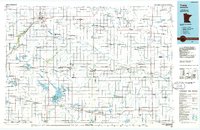 1986 Tracy1986 Print · USGSSouthwestern Minnesota's prairie rail towns and conservation lands are captured here in the mid-1980s. Researchers can trace the Chicago and North Western line through Walnut Grove or explore the many lakebeds and wildlife areas like Lake Sarah and Lake Shetek State Park.2 unique versions available
End of results
Showing maps 1-4 of 4
Top cities of Murray County
- Slayton historical maps
- Fulda historical maps
- Chandler historical maps
- Lake Wilson historical maps
- Currie historical maps
- Iona historical maps
See more
Frequently asked questions
- What are the different types of historical maps available for Murray County?
- What is the oldest map of Murray County?
- Where can I purchase historical maps of Murray County for my home or office?
- Where can I download high-res historical maps of Murray County?
- Are there historical topographic maps available for Murray County?
- Is there historical aerial imagery available for Murray County?
- Where are historical maps of Murray County sourced from?