1970s Maps of Nobles County, Minnesota
Explore 7 historic maps of Nobles County from the 1970s. These maps offer a rare glimpse into what life looked like during the 1970s — showing old roads, neighborhoods, homes, and landmarks that have changed or disappeared over time.
Whether you're researching your family's past, planning a metal detecting trip, or studying how Nobles County's landscape evolved across the 1970s, these high-resolution maps are a powerful tool for exploring the history of this region.
- Focus on a specific era: All maps on this page are from the 1970s, giving you a focused view of this time period.
- See what’s changed: Compare century-old streets, trails, and buildings to today's modern landscape using overlays and satellite layers.
- Research with precision: Use these maps for genealogy, historical research, land use analysis, or educational projects.
- View, download, or print: Maps are fully viewable online in high resolution, and can be downloaded or printed for your own records.
Start exploring Nobles County's history through authentic maps from the 1970s. This is your window into the past.
Nobles County, MN maps
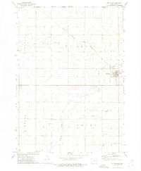
(7)- 1970 Map of Dundee, 1972 Print
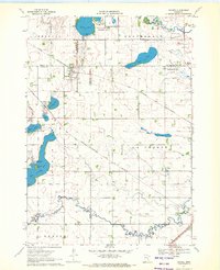 1970 Dundee1972 Print · USGSDundee and Kinbrae thrive at the junction of two major rail lines in this early 1970s landscape of the Minnesota prairie. Genealogists and local historians can trace family ties at St Marys Cemetery or Kinbrae Cemetery and explore the early wildlife management areas surrounding Talcot Lake and Graham Lake.2 unique versions available
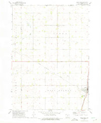
 - 1970 Map of Fulda, 1972 Print
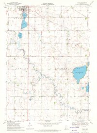 1970 Fulda1972 Print · USGSIn the early 1970s, the prairie town of Fulda remained a vital rail crossroads where the Chicago and North Western met the Milwaukee Road. Local historians can trace the development of the High School and the recreational lands surrounding West Graham Lake and Fulda Second Lake.
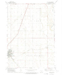
 - 1970 Map of Fulda SW, 1972 Print
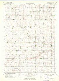 1970 Fulda SW1972 Print · USGSNobles and Murray Counties appear here in the early 1970s, showcasing a landscape of prairie townships and agricultural drainage. Researchers can locate the Seward Cem, the rural settlement at Pfingsten, and the path of the Chicago Milwaukee St Paul and Pacific railroad.
 - 1970 Map of Harris, 1972 Print
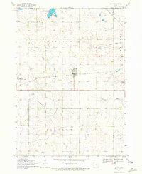 1970 Harris1972 Print · USGSOsceola County farmland is captured here in the early 1970s, centered on the railroad town of Harris. Genealogists and local historians can trace the paths of the Chicago Rock Island and Pacific or locate rural burials at Fairview Cem and Union Cem.
 - 1972 Map of Little Rock, 1975 Print
 1972 Little Rock1975 Print · USGSThe Lyon County prairie meets the Minnesota state line in the early 1970s, centered on the railroad crossing at Little Rock. Local researchers can trace family landmarks like Zion Cem, Bethel Ch, and the old Rock Island and Pacific rail line.
 - 1972 Map of Sibley West, 1975 Print
 1972 Sibley West1975 Print · USGSOsceola County at the start of the seventies shows a landscape defined by the intersection of major rail lines and a thriving agricultural grid. Genealogists can locate family sites near Holman Cem, Argo, and the Sibley town site.
 - 1972 Map of Sibley East, 1975 Print
 1972 Sibley East1975 Print · USGSOsceola County, Iowa, is captured in the early seventies as a thriving agricultural and rail hub. Genealogists and historians can trace the foundations of Sibley and Allendorf while locating family-named landmarks like North Sibley Cem and the local Townhall.
End of results
Showing maps 1-7 of 7
Top cities of Nobles County
- Worthington historical maps
- Adrian historical maps
- Ellsworth historical maps
- Brewster historical maps
- Leota historical maps
- Round Lake historical maps
See more
Frequently asked questions
- What are the different types of historical maps available for Nobles County?
- What is the oldest map of Nobles County?
- Where can I purchase historical maps of Nobles County for my home or office?
- Where can I download high-res historical maps of Nobles County?
- Are there historical topographic maps available for Nobles County?
- Is there historical aerial imagery available for Nobles County?
- Where are historical maps of Nobles County sourced from?