1910s Maps of Clitherall Township, Minnesota
Explore 4 historic maps of Clitherall Township from the 1910s. These maps offer a rare glimpse into what life looked like during the 1910s — showing old roads, neighborhoods, homes, and landmarks that have changed or disappeared over time.
Whether you're researching your family's past, planning a metal detecting trip, or studying how Clitherall Township's landscape evolved across the 1910s, these high-resolution maps are a powerful tool for exploring the history of this region.
- Focus on a specific era: All maps on this page are from the 1910s, giving you a focused view of this time period.
- See what’s changed: Compare century-old streets, trails, and buildings to today's modern landscape using overlays and satellite layers.
- Research with precision: Use these maps for genealogy, historical research, land use analysis, or educational projects.
- View, download, or print: Maps are fully viewable online in high resolution, and can be downloaded or printed for your own records.
Start exploring Clitherall Township's history through authentic maps from the 1910s. This is your window into the past.
Clitherall Township, MN maps
(4)- 1912 Map of Battle Lake, 1975 Print
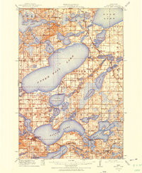 1912 Battle Lake1975 Print · USGSOtter Tail County is captured here in the early twentieth century, showing a lake-rich landscape being shaped by new railroads and summer tourism. Genealogists can locate nearly twenty numbered schoolhouses and early communities like Battle Lake, Vining, and Ottertail.
 - 1913 Map of Ashby
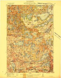
 1913 Ashby1913 Print · USGSBefore the modernization of the Midwest, this part of Minnesota was a patchwork of numbered school districts and vital rail lines. Genealogists can trace family footprints near Dalton or search for local landmarks like School No 81, Tenmile Lake, and the Northern Pacific RR.4 unique versions available
 - 1914 Map of Battle Lake
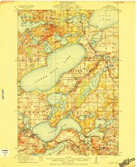 1914 Battle Lake1914 Print · USGSOtter Tail County’s lake country is captured here just before the Great War, showing a landscape defined by water and rail. Researchers can trace numerous rural schoolhouses and early lakeside retreats like Island Lodge, Camp Nidaros, and the village of Battle Lake.3 unique versions available
 - 1915 Map of Underwood
 1915 Underwood1915 Print · USGSOtter Tail County is shown here in the early twentieth century as a thriving network of small school districts and lakeside townships. You can trace the Northern Pacific rail line through Underwood or locate local landmarks like School No 207 Weggeland and Maine.3 unique versions available
End of results
Showing maps 1-4 of 4
Top cities near Clitherall Township
- Battle Lake historical maps
- Maine historical maps
- Ottertail historical maps
- Amor historical maps
- Ashby historical maps
- Underwood historical maps
See more
Frequently asked questions
- What are the different types of historical maps available for Clitherall Township?
- What is the oldest map of Clitherall Township?
- Where can I purchase historical maps of Clitherall Township for my home or office?
- Where can I download high-res historical maps of Clitherall Township?
- Are there historical topographic maps available for Clitherall Township?
- Is there historical aerial imagery available for Clitherall Township?
- Where are historical maps of Clitherall Township sourced from?