1970s Maps of Dane Prairie Township, Minnesota
Explore 4 historic maps of Dane Prairie Township from the 1970s. These maps offer a rare glimpse into what life looked like during the 1970s — showing old roads, neighborhoods, homes, and landmarks that have changed or disappeared over time.
Whether you're researching your family's past, planning a metal detecting trip, or studying how Dane Prairie Township's landscape evolved across the 1970s, these high-resolution maps are a powerful tool for exploring the history of this region.
- Focus on a specific era: All maps on this page are from the 1970s, giving you a focused view of this time period.
- See what’s changed: Compare century-old streets, trails, and buildings to today's modern landscape using overlays and satellite layers.
- Research with precision: Use these maps for genealogy, historical research, land use analysis, or educational projects.
- View, download, or print: Maps are fully viewable online in high resolution, and can be downloaded or printed for your own records.
Start exploring Dane Prairie Township's history through authentic maps from the 1970s. This is your window into the past.
Dane Prairie Township, MN maps
(4)- 1973 Map of Wall Lake, 1975 Print
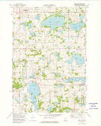 1973 Wall Lake1975 Print · USGSOtter Tail County's glacial lake country is captured here in the early 1970s as a landscape of rural townships and water-based industry. Local historians can trace family roots through the Swedish Ch Cem, Vang Cem, and the village of Underwood.
 - 1973 Map of Dalton, 1975 Print
 1973 Dalton1975 Print · USGSOtter Tail County's lake-rich landscape is captured here in the early 1970s, centered on the rail-side community of Dalton. Genealogists and local historians can trace the foundations of this farming region through the Sarpsborg Cem, Tenmile Lake Ch, and the winding Pomme de Terre River.
 - 1973 Map of Dayton Hollow Dam, 1975 Print
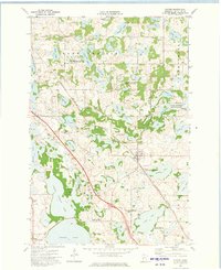
 1973 Dayton Hollow Dam1975 Print · USGSOtter Tail County in the early seventies reveals a landscape transition between agricultural townships and extensive conservation lands. Genealogists and historians can trace family locations near Ness and Squier, or locate old burials at Aastad Ch Cem.
 - 1973 Map of Fergus Falls, 1975 Print
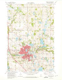 1973 Fergus Falls1975 Print · USGSFergus Falls in the early 1970s is a hub of industry and education along the Otter Tail River. Genealogists and historians can trace the grounds of the Fergus Falls State Hospital or locate burials at Oak Grove Cem and First Cem.2 unique versions available
End of results
Showing maps 1-4 of 4
Top cities near Dane Prairie Township
- Fergus Falls historical maps
- Battle Lake historical maps
- Maine historical maps
- Amor historical maps
- Ashby historical maps
- Underwood historical maps
See more
Top neighborhoods of Dane Prairie Township
Frequently asked questions
- What are the different types of historical maps available for Dane Prairie Township?
- What is the oldest map of Dane Prairie Township?
- Where can I purchase historical maps of Dane Prairie Township for my home or office?
- Where can I download high-res historical maps of Dane Prairie Township?
- Are there historical topographic maps available for Dane Prairie Township?
- Is there historical aerial imagery available for Dane Prairie Township?
- Where are historical maps of Dane Prairie Township sourced from?