1900s (20th Century) Maps of Mavis Frazier Trailer Park, Minnesota
Explore 8 historic maps of Mavis Frazier Trailer Park from the 1900s (20th Century). These maps offer a rare glimpse into what life looked like during the 1900s — showing old roads, neighborhoods, homes, and landmarks that have changed or disappeared over time.
Whether you're researching your family's past, planning a metal detecting trip, or studying how Mavis Frazier Trailer Park's landscape evolved across the 1900s, these high-resolution maps are a powerful tool for exploring the history of this region.
- Focus on a specific era: All maps on this page are from the 1900s, giving you a focused view of this time period.
- See what’s changed: Compare century-old streets, trails, and buildings to today's modern landscape using overlays and satellite layers.
- Research with precision: Use these maps for genealogy, historical research, land use analysis, or educational projects.
- View, download, or print: Maps are fully viewable online in high resolution, and can be downloaded or printed for your own records.
Start exploring Mavis Frazier Trailer Park's history through authentic maps from the 1900s. This is your window into the past.
Mavis Frazier Trailer Park, MN maps
(8)- 1912 Map of Vergas, 1969 Print
 1912 Vergas1969 Print · USGSOtter Tail County was a patchwork of glaciated lakes and early rail lines in the years preceding the Great War. You can trace the path of the Winnipeg Line through Vergas and locate over twenty rural school sites including Jacobs School and School No 116.
 - 1915 Map of Vergas
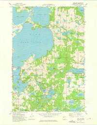
 1915 Vergas1915 Print · USGSThe lake country of Otter Tail and Becker counties is captured here in the early twentieth century as recreation began to meet rural industry. Researchers can find numerous country schoolhouses, early lodges like Pelican Inn, and the Fricke Mill site near Lake Melissa.6 unique versions available
 - 1953 Map of Brainerd, 1966 Print
 1953 Brainerd1966 Print · USGSCentral Minnesota's lake country and iron ranges are detailed in the mid-fifties, showing the intersection of industry and wilderness. Researchers can locate specific local landmarks like the Crow Wing County Courthouse or trace the early paths of the Soo Line Railroad and the Cuyuna Range Iron Mines.3 unique versions available
 - 1957 Map of Brainerd
 1957 Brainerd1957 Print · USGSNorth-central Minnesota's lake-rich landscape is captured in the mid-1950s as a crossroads of rail, river, and forest. Genealogists and historians can trace the paths of the Great Northern and Soo Line railroads through hubs like Brainerd, Wadena, and Detroit Lakes.
 - 1958 Map of Brainerd
 1958 Brainerd1958 Print · USGSCentral Minnesota in the late fifties is a landscape of dense lake chains, rail hubs, and sprawling state forests. Genealogists and local historians can trace old property alignments near the Mississippi River or locate family sites in Brainerd, Little Falls, and Detroit Lakes.
 - 1965 Map of Brainerd
 1965 Brainerd1965 Print · USGSNorth-central Minnesota in the mid-fifties presents a complex landscape of sprawling lake systems and established rail corridors. Genealogists and historians can trace the growth of timber towns along the Northern Pacific RR and explore early borders of the White Earth Indian Reservation or Tamarac National Wildlife Refuge.
 - 1973 Map of Lake Lida, 1975 Print
 1973 Lake Lida1975 Print · USGSThe lake-country of central Minnesota comes alive in the early seventies, showcasing a complex glacial landscape centered on Lake Lida. Genealogists and researchers can trace the early layout of Maplewood State Park and locate rural landmarks like Maplewood Ch or the West Spirit Lake shoreline.
 - 1986 Map of Detroit Lakes
 1986 Detroit Lakes1986 Print · USGSBecker and Otter Tail counties in the 1980s reveal a landscape of vast wildlife refuges and glacial lakes. Genealogists and historians can trace the rail corridor through Detroit Lakes and Perham or locate family sites near Sugar Bush Lake and Smoky Hill Lookout.2 unique versions available
End of results
Showing maps 1-8 of 8
Top cities near Mavis Frazier Trailer Park
- Detroit Lakes historical maps
- Pelican Rapids historical maps
- Lake Eunice historical maps
- Cormorant historical maps
- Maine historical maps
- Amor historical maps
See more
Frequently asked questions
- What are the different types of historical maps available for Mavis Frazier Trailer Park?
- What is the oldest map of Mavis Frazier Trailer Park?
- Where can I purchase historical maps of Mavis Frazier Trailer Park for my home or office?
- Where can I download high-res historical maps of Mavis Frazier Trailer Park?
- Are there historical topographic maps available for Mavis Frazier Trailer Park?
- Is there historical aerial imagery available for Mavis Frazier Trailer Park?
- Where are historical maps of Mavis Frazier Trailer Park sourced from?