1970s Maps of Richville, Minnesota
Explore 4 historic maps of Richville from the 1970s. These maps offer a rare glimpse into what life looked like during the 1970s — showing old roads, neighborhoods, homes, and landmarks that have changed or disappeared over time.
Whether you're researching your family's past, planning a metal detecting trip, or studying how Richville's landscape evolved across the 1970s, these high-resolution maps are a powerful tool for exploring the history of this region.
- Focus on a specific era: All maps on this page are from the 1970s, giving you a focused view of this time period.
- See what’s changed: Compare century-old streets, trails, and buildings to today's modern landscape using overlays and satellite layers.
- Research with precision: Use these maps for genealogy, historical research, land use analysis, or educational projects.
- View, download, or print: Maps are fully viewable online in high resolution, and can be downloaded or printed for your own records.
Start exploring Richville's history through authentic maps from the 1970s. This is your window into the past.
Richville, MN maps
(4)- 1973 Map of Ottertail, 1975 Print
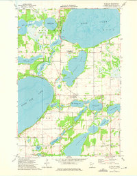 1973 Ottertail1975 Print · USGSThe lakeside community of Ottertail is shown at a time when the Soo Line railroad and local water recreation defined the area's rhythm. Genealogists and historians can locate several rural landmarks including Otter Tail Cem, Zion Cem, and the St John Sch.
 - 1973 Map of Dent, 1975 Print
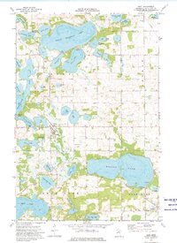 1973 Dent1975 Print · USGSThe village of Dent and the surrounding lakes are captured in the early 1970s as seasonal recreation and conservation efforts shaped the landscape. Genealogists and local historians can trace family plots at Pleasant Hill Cem or follow the Soo Line rail corridor past Richville.
 - 1973 Map of Walker Lake, 1975 Print
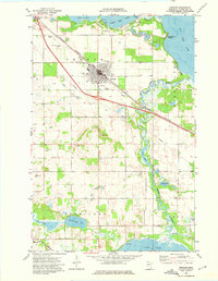
 1973 Walker Lake1975 Print · USGSOtter Tail County's lake-rich landscape is captured here in the early seventies, showing a period of dedicated conservation and quiet lakeside living. Trace family history or local sites at Amor, Oakwood Cem, and the Amor State Wildlife Management Area.
 - 1973 Map of Perham, 1975 Print
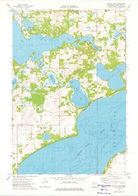
 1973 Perham1975 Print · USGSThe lakeside community of Perham is captured here in the early seventies, nestled among the glacial waters of Otter Tail County. Genealogists can trace family roots through several local landmarks like St Stanislaus Ch, Perham Cem, and the residential area at Grand View Heights.
End of results
Showing maps 1-4 of 4
Top cities near Richville
- Perham historical maps
- Frazee historical maps
- Battle Lake historical maps
- Henning historical maps
- Maine historical maps
- Ottertail historical maps
See more
Frequently asked questions
- What are the different types of historical maps available for Richville?
- What is the oldest map of Richville?
- Where can I purchase historical maps of Richville for my home or office?
- Where can I download high-res historical maps of Richville?
- Are there historical topographic maps available for Richville?
- Is there historical aerial imagery available for Richville?
- Where are historical maps of Richville sourced from?