1980s Maps of Rock Creek, Minnesota
Explore 8 historic maps of Rock Creek from the 1980s. These maps offer a rare glimpse into what life looked like during the 1980s — showing old roads, neighborhoods, homes, and landmarks that have changed or disappeared over time.
Whether you're researching your family's past, planning a metal detecting trip, or studying how Rock Creek's landscape evolved across the 1980s, these high-resolution maps are a powerful tool for exploring the history of this region.
- Focus on a specific era: All maps on this page are from the 1980s, giving you a focused view of this time period.
- See what’s changed: Compare century-old streets, trails, and buildings to today's modern landscape using overlays and satellite layers.
- Research with precision: Use these maps for genealogy, historical research, land use analysis, or educational projects.
- View, download, or print: Maps are fully viewable online in high resolution, and can be downloaded or printed for your own records.
Start exploring Rock Creek's history through authentic maps from the 1980s. This is your window into the past.
Rock Creek, MN maps
(8)- 1983 Map of Pine City, 1984 Print
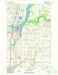 1983 Pine City1984 Print · USGSPine City and the Snake River corridor are captured here during the early 1980s, showcasing a landscape of lakeside development and rural transition. Local researchers can trace the Old Military Road, locate the Bohemian Cem, or find long-standing landmarks like the Drive-in Theater.
 - 1983 Map of Rush City, 1984 Print
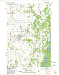 1983 Rush City1984 Print · USGSThe St. Croix River valley in the early 1980s shows a mix of established rail towns and protected state forests. Genealogists can locate family names at Taylor Cem and Sacred Heart Cem, or trace the path of the Old Military Road.
 - 1983 Map of Henriette, 1984 Print
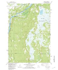
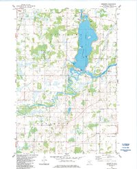 1983 Henriette1984 Print · USGSThe waters of Pokegama Lake and the Snake River define this Pine County landscape during the early 1980s. Local researchers can locate the Fur Post Historic Site, trace the Burlington Northern line through Henriette, and identify family landmarks like Tuxedo Bar.2 unique versions available
 - 1983 Map of Bass Creek, 1984 Print
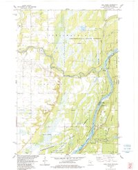 1983 Bass Creek1984 Print · USGSThe river valley along the Minnesota-Wisconsin border is shown here in the early eighties, showcasing the intersection of protected state lands and waterway navigation. Researchers can trace the courses of the Snake River and St Croix River while locating landmarks like Soderbeck Landing and Seven Islands.2 unique versions available
 - 1983 Map of Rush Lake, 1984 Print
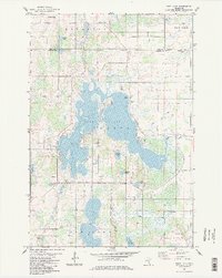 1983 Rush Lake1984 Print · USGSChisago County's lake country is captured here in the early eighties, showing a landscape defined by water and rural settlement. Genealogists can trace family footprints at Rush Point, Harris, or several local landmarks like Rush Lake Ch and St Johns Cem.2 unique versions available
 - 1983 Map of Randall, 1984 Print
 1983 Randall1984 Print · USGSThe St Croix River corridor and the wetlands of Burnett County are captured here in the early 1980s. Researchers can locate community landmarks like Pleasant Prairie Ch, the Sunrise Ferry Riverway, and the Lookout Tower.
 - 1985 Map of Grantsburg
 1985 Grantsburg1985 Print · USGSThe river borderlands of Minnesota and Wisconsin come alive in the mid-1980s, showcasing the intricate water networks and forest preserves of Burnett and Pine counties. Trace the rail lines of the Soo Line or find rural landmarks like Trade Lake Ch and Hildas Corner.2 unique versions available
 - 1985 Map of Mora
 1985 Mora1985 Print · USGSCentral Minnesota's river valleys and farming hubs are captured here in the mid-eighties, showing the region before significant modern expansion. Researchers can trace historic rail lines like the Burlington Northern and locate community landmarks in Mora, Milaca, and Princeton.
End of results
Showing maps 1-8 of 8
Top cities near Rock Creek
- North Branch historical maps
- Pine City historical maps
- Rush City historical maps
- Sunrise historical maps
- Grantsburg historical maps
- Harris historical maps
See more
Frequently asked questions
- What are the different types of historical maps available for Rock Creek?
- What is the oldest map of Rock Creek?
- Where can I purchase historical maps of Rock Creek for my home or office?
- Where can I download high-res historical maps of Rock Creek?
- Are there historical topographic maps available for Rock Creek?
- Is there historical aerial imagery available for Rock Creek?
- Where are historical maps of Rock Creek sourced from?