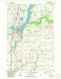
1983 Map of Pine City
USGS Topo · Published 1984About this map
The confluence of the Snake River and Cross Lake dictates the layout of Pine City in the early 1980s, where recreational boating and public access points meet the town's expanding residential grid. The Burlington Northern railroad corridor runs north-south, linking the city to the smaller settlement of Rock Creek to the south. Historically significant landmarks include the Old Military Road, which winds through the rural landscape, and a collection of family and community burial grounds such as Bohemian Cem and Pine Grove Cem. Cultural and industrial markers of the era are visible in the Drive-in Theater, the Municipal Airport, and the Sewage Disposal Ponds near the lake. The terrain transitions from the developed city center to the wooded tracts of Chengwatana and Pokegama, reflecting a balance between municipal growth and the natural hydrology of the Minnesota lakelands.
Find a feature on this map
38 named features on this map. Tap any name to fly to it.
Don’t see what you’re looking for? This feature index may not catch every label — zoom into the map to look around manually.
Map Details
Editions of this 1983 Pine City Map
This is the sole edition of this map. No revisions or reprints were ever made.
Other maps of this area

1950 · Rush City
USGS Topo · 1:48,000

1953 · Stillwater
USGS Topo · 1:250,000

1955 · Rush City
USGS Topo · 1:62,500

1955 · Stillwater
USGS Topo · 1:250,000

1958 · Stillwater
USGS Topo · 1:250,000

1961 · Cambridge
USGS Topo · 1:62,500

1961 · Brook Park
USGS Topo · 1:62,500

1961 · Pine City
USGS Topo · 1:62,500

1965 · Stillwater
USGS Topo · 1:250,000

1975 · Stillwater
USGS Topo · 1:250,000
Featured Places
- Pine City, MN
- Rock Creek, MN
- Pine City Township, MN
- Pokegama Township, MN
- Pine Terrace Mobile Home Park, Pine City