
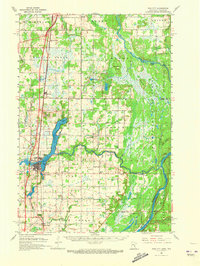
1961 Map of Pine City
USGS Topo · Published 1963About this map
Pine City serves as the focal point of this 1961 survey, situated at the confluence where the Snake River meets Cross Lake. The landscape is defined by the transition from agricultural fields in the west to the dense woodlands of the Chengwatana State Forest and St Croix State Forest along the Wisconsin border. A strong cultural heritage is evident through numerous rural landmarks, including the Bohemian Cem and Cech Cem, reflecting the area's immigrant settlement patterns. Transport and commerce are anchored by the Northern Pacific railroad and the emerging Interstate 35, while the St Croix River and Kettle River dominate the eastern topography. Scattered throughout the townships are over a dozen numbered schools, such as School No 1572 and School No 1573, indicating the density of the rural population at this time.
Find a feature on this map
68 named features on this map. Tap any name to fly to it.
Don’t see what you’re looking for? This feature index may not catch every label — zoom into the map to look around manually.
Map Details
Editions of this 1961 Pine City Map
2 editions found
Other maps of this area

1950 · Rush City
USGS Topo · 1:48,000

1950 · Grantsburg
USGS Topo · 1:48,000

1951 · Milltown
USGS Topo · 1:48,000

1953 · Duluth
USGS Topo · 1:250,000

1953 · Stillwater
USGS Topo · 1:250,000

1955 · Rush City
USGS Topo · 1:62,500

1955 · Milltown
USGS Topo · 1:62,500

1955 · Stillwater
USGS Topo · 1:250,000

1958 · Stillwater
USGS Topo · 1:250,000

1958 · Duluth
USGS Topo · 1:250,000