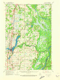
1961 Map of Pine City
USGS Topo · Published 1973About this map
Pine City serves as the focal point of this mid-century survey, situated at the confluence of the Snake River and Cross Lake. The landscape reflects a well-established rural infrastructure, evidenced by a dense network of numerically identified schools, such as School No 1584 and School No 1573, alongside several denominational or ethnic landmarks including Bohemian Cem and Milburn Ch. To the east, the terrain transitions into the dense woodlands of the Chengwatana State Forest, bounded by the winding St Croix River at the Wisconsin border.
Find a feature on this map
71 named features on this map. Tap any name to fly to it.
Don’t see what you’re looking for? This feature index may not catch every label — zoom into the map to look around manually.
Map Details
Editions of this 1961 Pine City Map
2 editions found

Other maps of this area

1950 · Rush City
USGS Topo · 1:48,000

1950 · Grantsburg
USGS Topo · 1:48,000

1951 · Milltown
USGS Topo · 1:48,000

1953 · Duluth
USGS Topo · 1:250,000

1953 · Stillwater
USGS Topo · 1:250,000

1955 · Rush City
USGS Topo · 1:62,500

1955 · Milltown
USGS Topo · 1:62,500

1955 · Stillwater
USGS Topo · 1:250,000

1958 · Stillwater
USGS Topo · 1:250,000

1958 · Duluth
USGS Topo · 1:250,000