1970s Maps of Trail, Minnesota
Explore 1 historic maps of Trail from the 1970s. These maps offer a rare glimpse into what life looked like during the 1970s — showing old roads, neighborhoods, homes, and landmarks that have changed or disappeared over time.
Whether you're researching your family's past, planning a metal detecting trip, or studying how Trail's landscape evolved across the 1970s, these high-resolution maps are a powerful tool for exploring the history of this region.
- Focus on a specific era: All maps on this page are from the 1970s, giving you a focused view of this time period.
- See what’s changed: Compare century-old streets, trails, and buildings to today's modern landscape using overlays and satellite layers.
- Research with precision: Use these maps for genealogy, historical research, land use analysis, or educational projects.
- View, download, or print: Maps are fully viewable online in high resolution, and can be downloaded or printed for your own records.
Start exploring Trail's history through authentic maps from the 1970s. This is your window into the past.
Trail, MN maps
(1)- 1972 Map of Trail, 1976 Print
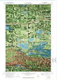 1972 Trail1976 Print · USGSThe border of Polk and Red Lake Counties comes into focus in the early 1970s, showing a landscape of drainage ditches and conservation areas. Researchers can locate St Charles Ch, the Mt Olive Cem, and traces of the Indian Reservation Line near the village of Trail.
End of results
Showing maps 1-1 of 1
Top cities near Trail
- Fosston historical maps
- McIntosh historical maps
- Oklee historical maps
- Gonvick historical maps
- Garnes historical maps
- Gully historical maps
Top neighborhoods of Trail
Frequently asked questions
- What are the different types of historical maps available for Trail?
- What is the oldest map of Trail?
- Where can I purchase historical maps of Trail for my home or office?
- Where can I download high-res historical maps of Trail?
- Are there historical topographic maps available for Trail?
- Is there historical aerial imagery available for Trail?
- Where are historical maps of Trail sourced from?