1960s Maps of Crooks Township, Minnesota
Explore 5 historic maps of Crooks Township from the 1960s. These maps offer a rare glimpse into what life looked like during the 1960s — showing old roads, neighborhoods, homes, and landmarks that have changed or disappeared over time.
Whether you're researching your family's past, planning a metal detecting trip, or studying how Crooks Township's landscape evolved across the 1960s, these high-resolution maps are a powerful tool for exploring the history of this region.
- Focus on a specific era: All maps on this page are from the 1960s, giving you a focused view of this time period.
- See what’s changed: Compare century-old streets, trails, and buildings to today's modern landscape using overlays and satellite layers.
- Research with precision: Use these maps for genealogy, historical research, land use analysis, or educational projects.
- View, download, or print: Maps are fully viewable online in high resolution, and can be downloaded or printed for your own records.
Start exploring Crooks Township's history through authentic maps from the 1960s. This is your window into the past.
Crooks Township, MN maps
(5)- 1965 Map of Danube, 1966 Print
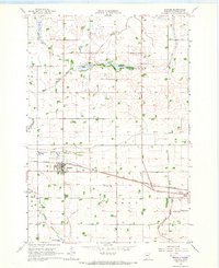 1965 Danube1966 Print · USGSRenville County farmland is captured here in the mid-1960s, showing the vital intersection of rail and road through Danube. Researchers can trace old family sites near the United Brethren Cem or follow the path of the Chicago Milwaukee St Paul and Pacific railroad.
 - 1965 Map of Blomkest, 1966 Print
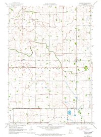 1965 Blomkest1966 Print · USGSThe prairie landscape of southern Kandiyohi County is captured here in the mid-1960s, showing a region defined by its rail-and-ditch infrastructure. Genealogists can trace the rural layout of Roseland, locate the Blomkest Cemetery, and follow the Chicago and North Western rail line.
 - 1965 Map of Renville, 1967 Print
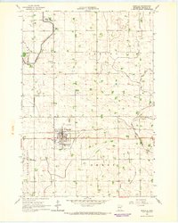 1965 Renville1967 Print · USGSRenville was a bustling prairie rail hub in the mid-1960s, defined by its connection to the Chicago Milwaukee St Paul and Pacific line. Genealogists and historians can trace local landmarks like Ebenezer Ch, Emden Cem, and the old city Townhall.
 - 1965 Map of Prinsburg, 1967 Print
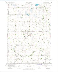 1965 Prinsburg1967 Print · USGSThe rural agricultural landscapes of Kandiyohi County are shown here in the mid-1960s as a complex network of managed drainage and rail transit. Researchers can locate community anchors like Prinsburg, Holland Cem, and School No 815 along the Chicago and North Western line.
 - 1967 Map of New Ulm
 1967 New Ulm1967 Print · USGSSouthern Minnesota in the mid-fifties is captured here as a landscape of river-valley missions and busy prairie rail towns. Researchers can trace the Yellow Medicine Trail and locate historic sites like the Morton Indian Mission and Milford State Monument.
End of results
Showing maps 1-5 of 5
Top cities near Crooks Township
- Olivia historical maps
- Clara City historical maps
- Renville historical maps
- Raymond historical maps
- Sacred Heart historical maps
- Roseland historical maps
See more
Frequently asked questions
- What are the different types of historical maps available for Crooks Township?
- What is the oldest map of Crooks Township?
- Where can I purchase historical maps of Crooks Township for my home or office?
- Where can I download high-res historical maps of Crooks Township?
- Are there historical topographic maps available for Crooks Township?
- Is there historical aerial imagery available for Crooks Township?
- Where are historical maps of Crooks Township sourced from?