1900s (20th Century) Maps of Roseau, Minnesota
Explore 9 historic maps of Roseau from the 1900s (20th Century). These maps offer a rare glimpse into what life looked like during the 1900s — showing old roads, neighborhoods, homes, and landmarks that have changed or disappeared over time.
Whether you're researching your family's past, planning a metal detecting trip, or studying how Roseau's landscape evolved across the 1900s, these high-resolution maps are a powerful tool for exploring the history of this region.
- Focus on a specific era: All maps on this page are from the 1900s, giving you a focused view of this time period.
- See what’s changed: Compare century-old streets, trails, and buildings to today's modern landscape using overlays and satellite layers.
- Research with precision: Use these maps for genealogy, historical research, land use analysis, or educational projects.
- View, download, or print: Maps are fully viewable online in high resolution, and can be downloaded or printed for your own records.
Start exploring Roseau's history through authentic maps from the 1900s. This is your window into the past.
Roseau, MN maps
(9)- 1918 Map of Goos
 1918 Goos1918 Print · USGSNorthern Minnesota near the Canadian border is shown during a period of massive land reclamation and rail expansion. Genealogists and historians can trace the early drainage network alongside the Great Northern tracks and locate sites like Salol, Mandus, and Boisvert.
 - 1918 Map of Roseau
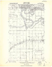 1918 Roseau1918 Print · USGSNorthern Minnesota’s borderlands come into focus at the end of the Great War, showing a landscape defined by water management and the rail. Trace early schoolhouse locations and rail crossings like Farm Xing near the Great Northern R. R. and Roseau Lake.2 unique versions available
 - 1943 Map of Goos
 1943 Goos1943 Print · USGSNorthwestern Minnesota territory along the international border is mapped here during the Second World War based on earlier military surveys. Researchers can trace the Great Northern rail line and locate early rural landmarks like Salol, Mandus, and various School sites.
 - 1954 Map of Roseau, 1969 Print
 1954 Roseau1969 Print · USGSNorthern Minnesota's borderlands come alive in the 1950s, showing a landscape defined by timber, water, and rail. Trace family roots through old schools and cemeteries near Roseau, Warroad, and the expansive Red Lake Indian Reservation.2 unique versions available
 - 1957 Map of Roseau
 1957 Roseau1957 Print · USGSThe international border and tribal lands define Northern Minnesota in the mid-fifties, from the shores of Lake of the Woods to the Red Lake Indian Reservation. Researchers can trace the path of the Great Northern railroad and locate isolated outposts like the U S Custom House and Ponemah.
 - 1958 Map of Roseau
 1958 Roseau1958 Print · USGSNorthern Minnesota's borderlands and vast lake country are captured here in the late fifties. Researchers can trace the Canadian National rail line through Warroad or find family history in frontier settlements like Baudette, Waskish, and Shotley.
 - 1966 Map of Malung, 1968 Print
 1966 Malung1968 Print · USGSRoseau County in the mid-1960s reveals a landscape defined by the winding Roseau River and the steady presence of the Great Northern railroad. Genealogists can locate family sites near Spruce Cem, Malung Hall, and the Roseau Municipal Airport.
 - 1966 Map of Roseau, 1968 Print
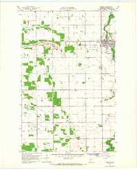 1966 Roseau1968 Print · USGSRoseau flourished in the mid-sixties as a vital rail and river hub for northern Minnesota agriculture. Genealogists can locate family sites at Sacred Heart Cem and Hope Cem, while tracing the influence of the Great Northern railroad and the Roseau River.2 unique versions available
 - 1976 Map of Roseau, 1994 Print
 1976 Roseau1994 Print · USGSThe Minnesota-Manitoba borderlands come into focus in the mid-seventies, showing the intersection of lake-shore life and the prairie's edge. Genealogists and historians can trace rail sidings and small settlements from Warroad to Roseau, or locate family landmarks near the Red Lake Indian Reservation and Arnesen.
End of results
Showing maps 1-9 of 9
Top cities near Roseau
Frequently asked questions
- What are the different types of historical maps available for Roseau?
- What is the oldest map of Roseau?
- Where can I purchase historical maps of Roseau for my home or office?
- Where can I download high-res historical maps of Roseau?
- Are there historical topographic maps available for Roseau?
- Is there historical aerial imagery available for Roseau?
- Where are historical maps of Roseau sourced from?