
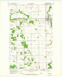
1966 Map of Malung
USGS Topo · Published 1968About this map
The Roseau River meanders through this portion of Roseau County, defining the landscape between the village of Roseau and the community of Malung. This 1960s survey documents a predominantly agricultural region where local life is centered around the Great Northern railroad line and key community landmarks. Researchers will find the Spruce Ch and Spruce Cem in the north, while the southern reach includes Malung Hall and the Malung Cem. The infrastructure of the era is represented by the Roseau Municipal Airport and Radio Towers (KRWB), reflecting mid-century modernization. Several Gravel Pit operations and a Sandpit are scattered throughout the township of Malung, indicating the local extractive industry that supported the county's road and rail network during this period.
Find a feature on this map
25 named features on this map. Tap any name to fly to it.
Don’t see what you’re looking for? This feature index may not catch every label — zoom into the map to look around manually.
Map Details
Editions of this 1966 Malung Map
This is the sole edition of this map. No revisions or reprints were ever made.
Other maps of this area

1918 · Goos
USGS Topo · 1:62,500

1918 · Pencer
USGS Topo · 1:62,500

1918 · Roseau
USGS Topo · 1:62,500

1918 · Garland
USGS Topo · 1:62,500

1943 · Goos
USGS Topo · 1:62,500

1954 · Roseau
USGS Topo · 1:250,000

1957 · Roseau
USGS Topo · 1:250,000

1958 · Roseau
USGS Topo · 1:250,000

1966 · Salol NW
USGS Topo · 1:24,000
1966 · Roseau
USGS Topo · 1:24,000