1990s Maps of Duluth, Minnesota
Explore 3 historic maps of Duluth from the 1990s. These maps offer a rare glimpse into what life looked like during the 1990s — showing old roads, neighborhoods, homes, and landmarks that have changed or disappeared over time.
Whether you're researching your family's past, planning a metal detecting trip, or studying how Duluth's landscape evolved across the 1990s, these high-resolution maps are a powerful tool for exploring the history of this region.
- Focus on a specific era: All maps on this page are from the 1990s, giving you a focused view of this time period.
- See what’s changed: Compare century-old streets, trails, and buildings to today's modern landscape using overlays and satellite layers.
- Research with precision: Use these maps for genealogy, historical research, land use analysis, or educational projects.
- View, download, or print: Maps are fully viewable online in high resolution, and can be downloaded or printed for your own records.
Start exploring Duluth's history through authentic maps from the 1990s. This is your window into the past.
Duluth, MN maps
(3)- 1992 Map of Lakewood, 1995 Print
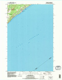 1992 Lakewood1995 Print · USGSThe North Shore of Lake Superior comes into focus in the early nineties as the outskirts of Duluth meet Lakewood. Trace the historic winding paths of Old North Shore Road and Lester River as they follow the rugged elevation of Moose Mountain.2 unique versions available
 - 1992 Map of French River, 1995 Print
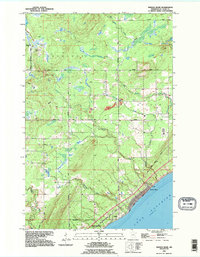 1992 French River1995 Print · USGSThe North Shore of Lake Superior comes alive in the early 1990s as it transitions from the forested township of Normanna to the shoreline. Researchers can trace the coastal settlement of Clifton or locate the Normanna Cem and several vital waterways like the French River.
 - 1997 Map of West Duluth, 1999 Print
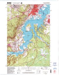 1997 West Duluth1999 Print · USGSThe industrial heart of the Twin Ports comes alive in this late-century study of the riverfront and its rail-connected neighborhoods. Genealogists and historians can trace family roots through Oneota Cemetery or locate old school sites like St Patricks Sch and Stowe Sch.
End of results
Showing maps 1-3 of 3
Top cities near Duluth
- Superior historical maps
- Hermantown historical maps
- Proctor historical maps
- Lakewood historical maps
- Parkland historical maps
- Fredenberg historical maps
See more
Top neighborhoods of Duluth
- Central Hillside historical maps
- North Shore historical maps
- Duluth Heights historical maps
- Lakeside-Lester Park historical maps
- Cody historical maps
- Oneota historical maps
See more
Frequently asked questions
- What are the different types of historical maps available for Duluth?
- What is the oldest map of Duluth?
- Where can I purchase historical maps of Duluth for my home or office?
- Where can I download high-res historical maps of Duluth?
- Are there historical topographic maps available for Duluth?
- Is there historical aerial imagery available for Duluth?
- Where are historical maps of Duluth sourced from?