1960s Maps of Meadowlands, Minnesota
Explore 2 historic maps of Meadowlands from the 1960s. These maps offer a rare glimpse into what life looked like during the 1960s — showing old roads, neighborhoods, homes, and landmarks that have changed or disappeared over time.
Whether you're researching your family's past, planning a metal detecting trip, or studying how Meadowlands's landscape evolved across the 1960s, these high-resolution maps are a powerful tool for exploring the history of this region.
- Focus on a specific era: All maps on this page are from the 1960s, giving you a focused view of this time period.
- See what’s changed: Compare century-old streets, trails, and buildings to today's modern landscape using overlays and satellite layers.
- Research with precision: Use these maps for genealogy, historical research, land use analysis, or educational projects.
- View, download, or print: Maps are fully viewable online in high resolution, and can be downloaded or printed for your own records.
Start exploring Meadowlands's history through authentic maps from the 1960s. This is your window into the past.
Meadowlands, MN maps
(2)- 1963 Map of Meadowlands, 1964 Print
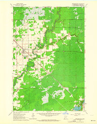 1963 Meadowlands1964 Print · USGSMeadowlands and the surrounding St. Louis County townships are shown in the early sixties as the regional rail and river networks shaped the landscape. Genealogists and locals can trace family landmarks like the Meadowlands Cem, the Witti Memorial Airport, and the winding Whiteface River.3 unique versions available
 - 1964 Map of Hibbing
 1964 Hibbing1964 Print · USGSNorthern Minnesota’s iron-rich corridor is captured here during a peak era of mid-century industrial activity. Researchers can trace the rail-to-mine connections through Mesabi Range towns like Hibbing and Virginia or locate lakefront settlements near Pokegama Lake.
End of results
Showing maps 1-2 of 2
Top cities near Meadowlands
- Hibbing historical maps
- Floodwood historical maps
- Alborn historical maps
- Culver historical maps
- Toivola historical maps
- Elmer historical maps
See more
Frequently asked questions
- What are the different types of historical maps available for Meadowlands?
- What is the oldest map of Meadowlands?
- Where can I purchase historical maps of Meadowlands for my home or office?
- Where can I download high-res historical maps of Meadowlands?
- Are there historical topographic maps available for Meadowlands?
- Is there historical aerial imagery available for Meadowlands?
- Where are historical maps of Meadowlands sourced from?