1960s Maps of Shermans Corner, Minnesota
Explore 2 historic maps of Shermans Corner from the 1960s. These maps offer a rare glimpse into what life looked like during the 1960s — showing old roads, neighborhoods, homes, and landmarks that have changed or disappeared over time.
Whether you're researching your family's past, planning a metal detecting trip, or studying how Shermans Corner's landscape evolved across the 1960s, these high-resolution maps are a powerful tool for exploring the history of this region.
- Focus on a specific era: All maps on this page are from the 1960s, giving you a focused view of this time period.
- See what’s changed: Compare century-old streets, trails, and buildings to today's modern landscape using overlays and satellite layers.
- Research with precision: Use these maps for genealogy, historical research, land use analysis, or educational projects.
- View, download, or print: Maps are fully viewable online in high resolution, and can be downloaded or printed for your own records.
Start exploring Shermans Corner's history through authentic maps from the 1960s. This is your window into the past.
Shermans Corner, MN maps
(2)- 1964 Map of Hibbing
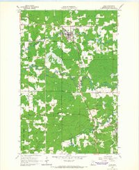
 1964 Hibbing1964 Print · USGSNorthern Minnesota’s iron-rich corridor is captured here during a peak era of mid-century industrial activity. Researchers can trace the rail-to-mine connections through Mesabi Range towns like Hibbing and Virginia or locate lakefront settlements near Pokegama Lake.
 - 1964 Map of Cook, 1966 Print
 1964 Cook1966 Print · USGSThe river-and-rail hub of Cook is captured here in the mid-1960s as it served the logging and farming families of St. Louis County. Researchers can trace rural church locations like Alango Ch and St Pauls Ch or follow the Duluth Winnipeg and Pacific rail line through Angora.2 unique versions available
End of results
Showing maps 1-2 of 2
Top cities near Shermans Corner
- Mountain Iron historical maps
- Cook historical maps
- Gheen historical maps
- Angora historical maps
- Linden Grove historical maps
- Willow Valley Township historical maps
See more
Frequently asked questions
- What are the different types of historical maps available for Shermans Corner?
- What is the oldest map of Shermans Corner?
- Where can I purchase historical maps of Shermans Corner for my home or office?
- Where can I download high-res historical maps of Shermans Corner?
- Are there historical topographic maps available for Shermans Corner?
- Is there historical aerial imagery available for Shermans Corner?
- Where are historical maps of Shermans Corner sourced from?