1950s Maps of Slim Lake, Minnesota
Explore 11 historic maps of Slim Lake from the 1950s. These maps offer a rare glimpse into what life looked like during the 1950s — showing old roads, neighborhoods, homes, and landmarks that have changed or disappeared over time.
Whether you're researching your family's past, planning a metal detecting trip, or studying how Slim Lake's landscape evolved across the 1950s, these high-resolution maps are a powerful tool for exploring the history of this region.
- Focus on a specific era: All maps on this page are from the 1950s, giving you a focused view of this time period.
- See what’s changed: Compare century-old streets, trails, and buildings to today's modern landscape using overlays and satellite layers.
- Research with precision: Use these maps for genealogy, historical research, land use analysis, or educational projects.
- View, download, or print: Maps are fully viewable online in high resolution, and can be downloaded or printed for your own records.
Start exploring Slim Lake's history through authentic maps from the 1950s. This is your window into the past.
Slim Lake, MN maps
(11)- 1954 Map of Two Harbors, 1964 Print
 1954 Two Harbors1964 Print · USGSThe Minnesota North Shore and Superior National Forest are shown here in the mid-fifties, just as the taconite industry was reshaping the coast. Genealogists and historians can trace the rail lines of the Duluth Missabe and Iron Range or locate remote outposts like Sawbill Landing and Section Thirty.2 unique versions available
 - 1954 Map of Hibbing, 1966 Print
 1954 Hibbing1966 Print · USGSNorthern Minnesota's Iron Range thrives during the mid-1960s, showing the industrial landscape between the Mesabi Range and the Mississippi River. Genealogists and historians can trace the rail lines of the Great Northern RR through mining hubs like Hibbing and Virginia.3 unique versions available
 - 1954 Map of International Falls, 1980 Print
 1954 International Falls1980 Print · USGSThe Minnesota-Ontario borderlands come alive in this mid-century survey of the Rainy River region and the interconnected waterways that now form Voyageurs National Park. Genealogists and local historians can trace the rail-and-timber era through settlements like Littlefork, the Nett Lake Indian Reservation, and the Canadian National rail lines.
 - 1956 Map of Crab Lake, 1958 Print
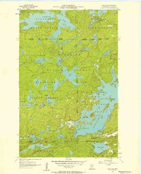 1956 Crab Lake1958 Print · USGSThe Iron Range lake country of the mid-1950s is captured here in detail, showing a wilderness of water and forest. Researchers can trace the convoluted shorelines of Burntside Lake and Crab Lake or locate islands like Pine Island and Shellman Island.3 unique versions available
 - 1957 Map of Two Harbors
 1957 Two Harbors1957 Print · USGSMinnesota's North Shore and the Arrowhead region are shown here in the mid-fifties as the taconite industry and cold war defense shaped the landscape. Researchers can trace the Duluth Missabe and Iron Range railroad, locate the Split Rock Light, and explore the iron-mining era at Taconite.
 - 1957 Map of Hibbing
 1957 Hibbing1957 Print · USGSNorthern Minnesota's Iron Range is shown at its industrial peak in the mid-fifties, dominated by the massive iron pits and rail corridors of the Mesabi Range. Researchers can trace the rail networks of the Duluth Missabe and Iron Range and locate mining hubs like Hibbing, Virginia, and Bovey.
 - 1957 Map of International Falls
 1957 International Falls1957 Print · USGSThe Minnesota-Ontario borderlands come alive in the mid-fifties, showing the industrial nodes of International Falls and Fort Frances. Genealogists and historians can trace rail-tied settlements like Aylsworth and Littlefork or locate ancestral lands within the Nett Lake Indian Reservation.
 - 1957 Map of Quetico, 1967 Print
 1957 Quetico1967 Print · USGSThe Ontario-Minnesota borderlands are captured here in the mid-fifties, showing the vast wilderness of the Boundary Waters before modern development. Genealogists and researchers can trace rail settlements along the Canadian National Railways including Atikokan, Sapawe, and Kashabowie.2 unique versions available
 - 1958 Map of International Falls
 1958 International Falls1958 Print · USGSThe borderlands of northern Minnesota and Ontario are mapped here during the mid-fifties, centered on the river-and-rail hubs of the Northwoods. Researchers can trace the path of the Northern Pacific through Big Falls or locate early settlements like Ericsburg and Ranier.2 unique versions available
 - 1958 Map of Hibbing
 1958 Hibbing1958 Print · USGSThe Mesabi Iron Range reached its mid-century height during this era, defining the landscape between Grand Rapids and Virginia. Genealogists and historians can trace the mining-town networks of Hibbing and Chisholm or locate numerous iron mines and rail spurs.
 - 1958 Map of Two Harbors
 1958 Two Harbors1958 Print · USGSThe North Shore and Arrowhead region of Minnesota are captured in the 1950s as iron ore shipping and wilderness preservation shaped the land. Researchers can trace the Duluth Missabe and Iron Range RR, find maritime landmarks like Split Rock Light, and locate remote settlements from Babbitt to Grand Marais.
End of results
Showing maps 1-11 of 11
Top cities near Slim Lake
Frequently asked questions
- What are the different types of historical maps available for Slim Lake?
- What is the oldest map of Slim Lake?
- Where can I purchase historical maps of Slim Lake for my home or office?
- Where can I download high-res historical maps of Slim Lake?
- Are there historical topographic maps available for Slim Lake?
- Is there historical aerial imagery available for Slim Lake?
- Where are historical maps of Slim Lake sourced from?