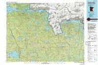
1970s Maps of Slim Lake, Minnesota
Explore 2 historic maps of Slim Lake from the 1970s. These maps offer a rare glimpse into what life looked like during the 1970s — showing old roads, neighborhoods, homes, and landmarks that have changed or disappeared over time.
Whether you're researching your family's past, planning a metal detecting trip, or studying how Slim Lake's landscape evolved across the 1970s, these high-resolution maps are a powerful tool for exploring the history of this region.
- Focus on a specific era: All maps on this page are from the 1970s, giving you a focused view of this time period.
- See what’s changed: Compare century-old streets, trails, and buildings to today's modern landscape using overlays and satellite layers.
- Research with precision: Use these maps for genealogy, historical research, land use analysis, or educational projects.
- View, download, or print: Maps are fully viewable online in high resolution, and can be downloaded or printed for your own records.
Start exploring Slim Lake's history through authentic maps from the 1970s. This is your window into the past.
Slim Lake, MN maps
(2)- 1977 Map of Basswood Lake, 1994 Print
 1977 Basswood Lake1994 Print · USGSThe Boundary Waters and Ontario’s wilderness meet in the late seventies across a vast network of interconnected glacial lakes. Researchers can trace the international line through Basswood Lake, Crooked Lake, and around the massive Hunter Island.
 - 1978 Map of Crane Lake, 1994 Print
 1978 Crane Lake1994 Print · USGSThe Minnesota-Ontario borderlands remained a dense wilderness of lakes and timber late into the twentieth century. Genealogists and historians can trace the route of the Duluth Winnipeg and Pacific through Orr and locate remote landmarks like Cemetery Island or the Beatty Portage.
End of results
Showing maps 1-2 of 2
Top cities near Slim Lake
Frequently asked questions
- What are the different types of historical maps available for Slim Lake?
- What is the oldest map of Slim Lake?
- Where can I purchase historical maps of Slim Lake for my home or office?
- Where can I download high-res historical maps of Slim Lake?
- Are there historical topographic maps available for Slim Lake?
- Is there historical aerial imagery available for Slim Lake?
- Where are historical maps of Slim Lake sourced from?