1900s (20th Century) Maps of Virginia, Minnesota
Explore 11 historic maps of Virginia from the 1900s (20th Century). These maps offer a rare glimpse into what life looked like during the 1900s — showing old roads, neighborhoods, homes, and landmarks that have changed or disappeared over time.
Whether you're researching your family's past, planning a metal detecting trip, or studying how Virginia's landscape evolved across the 1900s, these high-resolution maps are a powerful tool for exploring the history of this region.
- Focus on a specific era: All maps on this page are from the 1900s, giving you a focused view of this time period.
- See what’s changed: Compare century-old streets, trails, and buildings to today's modern landscape using overlays and satellite layers.
- Research with precision: Use these maps for genealogy, historical research, land use analysis, or educational projects.
- View, download, or print: Maps are fully viewable online in high resolution, and can be downloaded or printed for your own records.
Start exploring Virginia's history through authentic maps from the 1900s. This is your window into the past.
Virginia, MN maps
(11)- 1950 Map of Mc Kinley, 1960 Print
 1950 Mc Kinley1960 Print · USGSIron mining communities and the Duluth Missabe and Iron Range railroad define this mid-century survey of the Mesabi Range. Local historians can trace the industrial footprint of the Corsica Mine and the early layouts of McKinley and Elcor.4 unique versions available
 - 1951 Map of Mc Kinley
 1951 Mc Kinley1951 Print · USGSThe Mesabi Range’s industrial landscape comes into focus during the early fifties, showing a network of iron mines and company towns. Genealogists and historians can trace the foundations of McKinley, Elcor, and the Corsica Mine alongside the Duluth Missabe and Iron Range railroad.2 unique versions available
 - 1951 Map of Gilbert, 1952 Print
 1951 Gilbert1952 Print · USGSThe Mesabi Range iron industry is in full production during the early fifties, centering on the rail hubs and open pits of Gilbert and Sparta. Genealogists and historians can trace the footprints of the Gilbert Mine, Gilbert Cem, and the D M & I R railroad.4 unique versions available
 - 1951 Map of Eveleth, 1952 Print
 1951 Eveleth1952 Print · USGSThe Mesabi Iron Range hums with industrial activity in the early fifties, showing the massive pits and rail lines that drove the regional economy. Genealogists and historians can locate family homes near Leonidas, trace the Duluth Missabe and Iron Range tracks, or find old landmarks like Fayal Sch and the Virginia Mine.5 unique versions available
 - 1951 Map of Virginia, 1952 Print
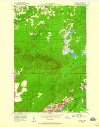
 1951 Virginia1952 Print · USGSThe Mesabi Range's industrial peak is on full display in the early fifties, showing a landscape defined by massive iron mines and railroad junctions. Genealogists and researchers can trace the neighborhoods of Mountain Iron and Parkville or locate specific sites like Greenwood Cemetery and Rainy Junction.9 unique versions available
 - 1954 Map of Hibbing, 1966 Print
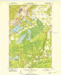
 1954 Hibbing1966 Print · USGSNorthern Minnesota's Iron Range thrives during the mid-1960s, showing the industrial landscape between the Mesabi Range and the Mississippi River. Genealogists and historians can trace the rail lines of the Great Northern RR through mining hubs like Hibbing and Virginia.3 unique versions available
 - 1957 Map of Hibbing
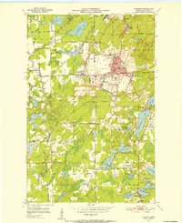
 1957 Hibbing1957 Print · USGSNorthern Minnesota's Iron Range is shown at its industrial peak in the mid-fifties, dominated by the massive iron pits and rail corridors of the Mesabi Range. Researchers can trace the rail networks of the Duluth Missabe and Iron Range and locate mining hubs like Hibbing, Virginia, and Bovey.
 - 1958 Map of Hibbing
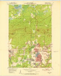
 1958 Hibbing1958 Print · USGSThe Mesabi Iron Range reached its mid-century height during this era, defining the landscape between Grand Rapids and Virginia. Genealogists and historians can trace the mining-town networks of Hibbing and Chisholm or locate numerous iron mines and rail spurs.
 - 1964 Map of Hibbing
 1964 Hibbing1964 Print · USGSNorthern Minnesota’s iron-rich corridor is captured here during a peak era of mid-century industrial activity. Researchers can trace the rail-to-mine connections through Mesabi Range towns like Hibbing and Virginia or locate lakefront settlements near Pokegama Lake.
 - 1977 Map of Hibbing, 1994 Print
 1977 Hibbing1994 Print · USGSThe Iron Range of northern Minnesota comes into sharp focus during the late seventies, detailing the massive mining works and rail networks of St. Louis County. Researchers can trace family roots in Hibbing, Chisholm, and Virginia, or locate old post offices like Leoneth and Iron.
 - 1994 Map of Vermillion Lake
 1994 Vermillion Lake1994 Print · USGSThe Mesabi Iron Range meets the North Woods in the 1990s, showcasing the heavy industrial footprint of the Duluth Missabe & Iron Range RR. Trace the sprawling works of the Mines near Virginia or the intricate island shorelines of Vermilion Lake.
End of results
Showing maps 1-11 of 11
Top cities near Virginia
- Eveleth historical maps
- Mountain Iron historical maps
- Gilbert historical maps
- Midway historical maps
- Biwabik historical maps
- Cherry historical maps
See more
Top neighborhoods of Virginia
Frequently asked questions
- What are the different types of historical maps available for Virginia?
- What is the oldest map of Virginia?
- Where can I purchase historical maps of Virginia for my home or office?
- Where can I download high-res historical maps of Virginia?
- Are there historical topographic maps available for Virginia?
- Is there historical aerial imagery available for Virginia?
- Where are historical maps of Virginia sourced from?