1960s Maps of Sherburne County, Minnesota
Explore 15 historic maps of Sherburne County from the 1960s. These maps offer a rare glimpse into what life looked like during the 1960s — showing old roads, neighborhoods, homes, and landmarks that have changed or disappeared over time.
Whether you're researching your family's past, planning a metal detecting trip, or studying how Sherburne County's landscape evolved across the 1960s, these high-resolution maps are a powerful tool for exploring the history of this region.
- Focus on a specific era: All maps on this page are from the 1960s, giving you a focused view of this time period.
- See what’s changed: Compare century-old streets, trails, and buildings to today's modern landscape using overlays and satellite layers.
- Research with precision: Use these maps for genealogy, historical research, land use analysis, or educational projects.
- View, download, or print: Maps are fully viewable online in high resolution, and can be downloaded or printed for your own records.
Start exploring Sherburne County's history through authentic maps from the 1960s. This is your window into the past.
Sherburne County, MN maps
(15)- 1961 Map of Clear Lake, 1963 Print
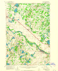
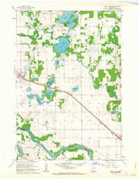 1961 Clear Lake1963 Print · USGSIn the early 1960s, this area of central Minnesota was defined by its glacial lakes and the rail corridor connecting Clear Lake and Becker. Researchers can trace family history through the Cem and local landmarks like the Aqueduct or Mosford Lake.3 unique versions available
 - 1961 Map of Big Lake, 1963 Print
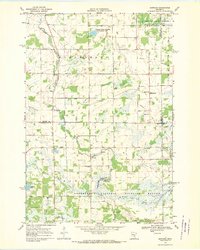
 1961 Big Lake1963 Print · USGSSherburne County and the upper Mississippi corridor are shown here in the early sixties as a network of rail and river commerce. Genealogists and local historians can trace the town of Big Lake, the settlement of Bailey, and the old Great Northern rail lines.2 unique versions available
 - 1961 Map of Silver Creek, 1963 Print
 1961 Silver Creek1963 Print · USGSWright County in the early 1960s was a landscape of glacial lakes and small rail-side settlements. Researchers can locate family landmarks like Highland Cem, the Carter Sch, and the local Silver Creek Ch along the Great Northern line.2 unique versions available
 - 1961 Map of Orrock, 1963 Print
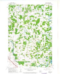
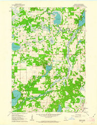 1961 Orrock1963 Print · USGSSherburne County in the early sixties was a patchwork of state-managed forest and tight-knit farming communities. Genealogists can trace early families at Galbraith Cem or Svea Hill Ch and locate landmarks like the Sand Dunes Lookout Tower.3 unique versions available
 - 1961 Map of Lake Fremont, 1963 Print
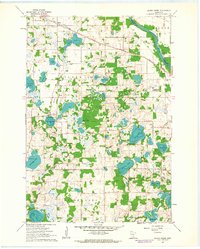
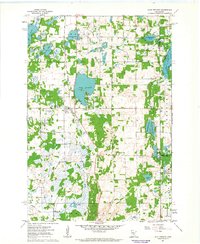 1961 Lake Fremont1963 Print · USGSSherburne County is shown here in the early sixties as a region of dense glacial lakes and burgeoning township life. Researchers can find family sites near Zimmerman, Livonia Cem, and the old Community Hall.3 unique versions available
 - 1961 Map of Elk River, 1963 Print
 1961 Elk River1963 Print · USGSElk River and the banks of the Mississippi River are captured here in the early sixties as the region's rail and water network defined local life. Genealogists and local historians can trace landmarks like St Andrews Cem, St Johns Sch, and the riverside powerplant.3 unique versions available
 - 1961 Map of Monticello, 1963 Print
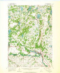
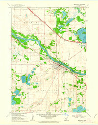 1961 Monticello1963 Print · USGSThe riverfront communities of Monticello and Big Lake are captured in the early sixties as they developed along the Mississippi River. Researchers can trace old family plots at Hillside Cemetery and Helm Cemetery or locate the historic Great Northern rail lines.3 unique versions available
 - 1961 Map of Becker, 1963 Print
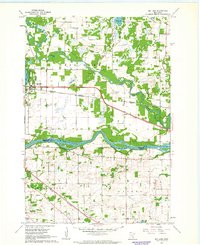
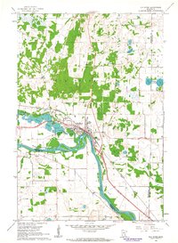
 1961 Becker1963 Print · USGSBecker and the surrounding Sherburne County wetlands are captured here in the early sixties as the rail and river economy shaped the landscape. Genealogists can locate family landmarks like Danish Cem, Krager Sch, and Durgin Slough.
 - 1961 Map of Monticello, 1965 Print
 1961 Monticello1965 Print · USGSUpper Mississippi valley river towns and rail corridors thrive here during the early sixties, caught between the prairie and the Big Woods. Researchers can trace family sites at St Henrys Cem, locate the Carter Sch, or follow the twin rail lines of the Great Northern and Northern Pacific.3 unique versions available
 - 1961 Map of Elk River, 1965 Print
 1961 Elk River1965 Print · USGSThe Elk River and Mississippi River valleys in the early 1960s showcase a landscape of shifting industry and conservation. Local researchers can trace family sites at Orrock Cem, find Zimmerman's post office, and locate the Sand Dunes Lookout Tower.
 - 1965 Map of Stillwater
 1965 Stillwater1965 Print · USGSThe Twin Cities and the St. Croix Valley are mapped here during a period of significant post-war growth and industrial transit. Genealogists and historians can trace rail lines like the Northern Pacific RR through towns such as Rush City, Amery, and Balsam Lake.
 - 1968 Map of Santiago, 1970 Print
 1968 Santiago1970 Print · USGSSherburne and Benton counties were characterized by quiet agricultural townships and spreading wildlife preserves during the late sixties. Genealogists and local historians can trace the foundations of Santiago and Glendorado, locating Oak Hill Cem and numerous schoolhouses.
 - 1968 Map of Princeton SW, 1970 Print
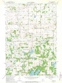
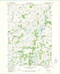 1968 Princeton SW1970 Print · USGSMille Lacs and Sherburne counties were a mosaic of wetlands and wildlife management areas in the late sixties. Researchers can trace rural landmarks and drainage networks, including the Greenbush Cem, the St Francis River, and the Townhall near Battle Brook.2 unique versions available
 - 1968 Map of Princeton, 1970 Print
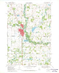 1968 Princeton1970 Print · USGSPrinceton and the surrounding Minnesota lake country are captured here in the late sixties as the town established its modern footprint. Trace local family history and rural development through landmarks like Brickton, Ebenezer Cem, and the Great Northern rail line.2 unique versions available
 - 1968 Map of Duelm, 1970 Print
 1968 Duelm1970 Print · USGSBenton and Sherburne counties appear in the late sixties as a landscape of glacial lakes and quiet township crossroads. Genealogists and local historians can locate St Lawrence Cemetery, School No 119, and the lakeside settlement of Duelm.
End of results
Showing maps 1-15 of 15
Top cities of Sherburne County
Frequently asked questions
- What are the different types of historical maps available for Sherburne County?
- What is the oldest map of Sherburne County?
- Where can I purchase historical maps of Sherburne County for my home or office?
- Where can I download high-res historical maps of Sherburne County?
- Are there historical topographic maps available for Sherburne County?
- Is there historical aerial imagery available for Sherburne County?
- Where are historical maps of Sherburne County sourced from?