1970s Maps of Sherburne County, Minnesota
Explore 5 historic maps of Sherburne County from the 1970s. These maps offer a rare glimpse into what life looked like during the 1970s — showing old roads, neighborhoods, homes, and landmarks that have changed or disappeared over time.
Whether you're researching your family's past, planning a metal detecting trip, or studying how Sherburne County's landscape evolved across the 1970s, these high-resolution maps are a powerful tool for exploring the history of this region.
- Focus on a specific era: All maps on this page are from the 1970s, giving you a focused view of this time period.
- See what’s changed: Compare century-old streets, trails, and buildings to today's modern landscape using overlays and satellite layers.
- Research with precision: Use these maps for genealogy, historical research, land use analysis, or educational projects.
- View, download, or print: Maps are fully viewable online in high resolution, and can be downloaded or printed for your own records.
Start exploring Sherburne County's history through authentic maps from the 1970s. This is your window into the past.
Sherburne County, MN maps
(5)- 1974 Map of Cable, 1976 Print
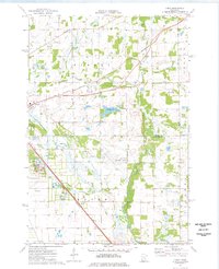 1974 Cable1976 Print · USGSBenton and Sherburne counties appear in the mid-seventies during a period of industrial and municipal expansion along the Elk River. Researchers can locate the State Reformatory, the Drive-in Theater, and the historic Cable station site along the Burlington Northern line.2 unique versions available
 - 1974 Map of St Augusta, 1976 Print
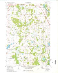 1974 St Augusta1976 Print · USGSStearns County was undergoing significant infrastructure growth in the mid-1970s as new highway routes were developed alongside the historic river corridor. Genealogists and local historians can trace family roots through sites like St Marys Cem, the settlement of Luxemburg, and the waters of Beaver Lake.
 - 1974 Map of St. Cloud, 1976 Print
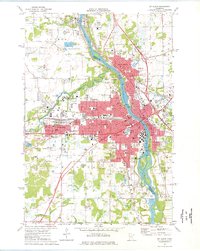 1974 St. Cloud1976 Print · USGSMid-century development in the St Cloud area is captured here as the city expanded across the Mississippi River. Researchers can trace the layout of St Cloud State College and locate numerous historical burial grounds like North Star Cem and St Joseph Cem.2 unique versions available
 - 1974 Map of Clearwater, 1976 Print
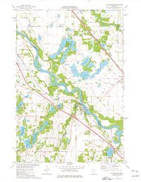 1974 Clearwater1976 Print · USGSThe tri-county junction of Sherburne, Stearns, and Wright counties comes alive in the mid-1970s as the river-and-rail economy centers on Clearwater. Local historians and genealogists can pinpoint specific family landmarks such as St Marcus Cem, Clearview Sch, and the winding path of Plum Creek.
 - 1975 Map of Stillwater
 1975 Stillwater1975 Print · USGSThe Twin Cities and the St. Croix Valley are captured in the mid-seventies, showing the urban growth of Minneapolis and St Paul. Researchers can trace old rail corridors of the Northern Pacific RR and locate tribal lands at the Mille Lacs Indian Reservation.2 unique versions available
End of results
Showing maps 1-5 of 5
Top cities of Sherburne County
Frequently asked questions
- What are the different types of historical maps available for Sherburne County?
- What is the oldest map of Sherburne County?
- Where can I purchase historical maps of Sherburne County for my home or office?
- Where can I download high-res historical maps of Sherburne County?
- Are there historical topographic maps available for Sherburne County?
- Is there historical aerial imagery available for Sherburne County?
- Where are historical maps of Sherburne County sourced from?