1970s Maps of Stearns County, Minnesota
Explore 10 historic maps of Stearns County from the 1970s. These maps offer a rare glimpse into what life looked like during the 1970s — showing old roads, neighborhoods, homes, and landmarks that have changed or disappeared over time.
Whether you're researching your family's past, planning a metal detecting trip, or studying how Stearns County's landscape evolved across the 1970s, these high-resolution maps are a powerful tool for exploring the history of this region.
- Focus on a specific era: All maps on this page are from the 1970s, giving you a focused view of this time period.
- See what’s changed: Compare century-old streets, trails, and buildings to today's modern landscape using overlays and satellite layers.
- Research with precision: Use these maps for genealogy, historical research, land use analysis, or educational projects.
- View, download, or print: Maps are fully viewable online in high resolution, and can be downloaded or printed for your own records.
Start exploring Stearns County's history through authentic maps from the 1970s. This is your window into the past.
Stearns County, MN maps
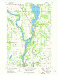
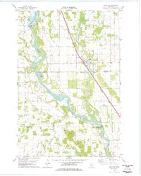
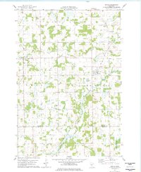
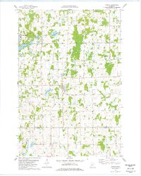
(10)- 1974 Map of St Augusta, 1976 Print
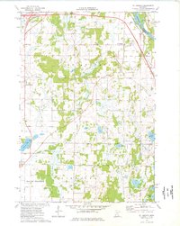 1974 St Augusta1976 Print · USGSStearns County was undergoing significant infrastructure growth in the mid-1970s as new highway routes were developed alongside the historic river corridor. Genealogists and local historians can trace family roots through sites like St Marys Cem, the settlement of Luxemburg, and the waters of Beaver Lake.
 - 1974 Map of Annandale, 1976 Print
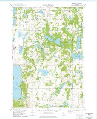
 1974 Annandale1976 Print · USGSThe lake country of central Minnesota flourished in the 1970s as a hub for both industry and recreation. Genealogists and historians can trace the Soo Line rail corridor through Annandale or locate family sites at Woodlawn Cem and St Marks Ch.
 - 1974 Map of St. Cloud, 1976 Print
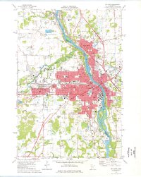 1974 St. Cloud1976 Print · USGSMid-century development in the St Cloud area is captured here as the city expanded across the Mississippi River. Researchers can trace the layout of St Cloud State College and locate numerous historical burial grounds like North Star Cem and St Joseph Cem.2 unique versions available
 - 1974 Map of South Haven, 1976 Print
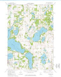
 1974 South Haven1976 Print · USGSThe lake-dotted border of Stearns and Wright counties comes into focus in the mid-seventies, showing the vital role of the SOO LINE railroad. Family historians can trace local roots through Zion Cem, Fairhaven, and St Johns Cem near Annandale.
 - 1974 Map of Little Rock Lake, 1976 Print
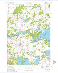
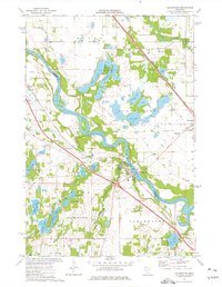
 1974 Little Rock Lake1976 Print · USGSBenton and Stearns County river life in the mid-seventies centers on the winding Mississippi River and the shores of Little Rock Lake. Researchers can trace early transportation and industry through the Burlington Northern line and local landmarks like Rice Cem and Watab.3 unique versions available
 - 1974 Map of Clearwater, 1976 Print
 1974 Clearwater1976 Print · USGSThe tri-county junction of Sherburne, Stearns, and Wright counties comes alive in the mid-1970s as the river-and-rail economy centers on Clearwater. Local historians and genealogists can pinpoint specific family landmarks such as St Marcus Cem, Clearview Sch, and the winding path of Plum Creek.
 - 1978 Map of Royalton
 1978 Royalton1978 Print · USGSThe Mississippi and Platte rivers converge in this late 1970s survey of central Minnesota, capturing the rail-and-river economy of the day. Genealogists can trace local roots at Holy Trinity Cem and Royalton Cem, or locate family landmarks near North Prairie and Blanchard Dam.
 - 1978 Map of Bowlus
 1978 Bowlus1978 Print · USGSMorrison County's rural rail and river landscape is preserved here in the late seventies, centered on the Soo Line through Bowlus. Genealogists and local historians can locate St Mary Cem, South Elmdale Sch, and the village of Elmdale.
 - 1978 Map of Upsala
 1978 Upsala1978 Print · USGSCentral Minnesota farm and lake country comes to life in the late seventies, centered on the village of Upsala. Genealogists and local researchers can pinpoint family landmarks like St Marys Cem, the St Francis church, and Lake Beautiful.
 - 1978 Map of Burtrum
 1978 Burtrum1978 Print · USGSThe lake-strewn landscape of central Minnesota is seen here in the late seventies at the junction of three counties. Local historians can trace the lakeside developments at North Shore and Pleasant Beach or locate family sites near the G A R Cem and Burtrum.
End of results
Showing maps 1-10 of 10
Top cities of Stearns County
- Sartell historical maps
- Waite Park historical maps
- Sauk Centre historical maps
- Cold Spring historical maps
- Melrose historical maps
- Rockville historical maps
See more
Frequently asked questions
- What are the different types of historical maps available for Stearns County?
- What is the oldest map of Stearns County?
- Where can I purchase historical maps of Stearns County for my home or office?
- Where can I download high-res historical maps of Stearns County?
- Are there historical topographic maps available for Stearns County?
- Is there historical aerial imagery available for Stearns County?
- Where are historical maps of Stearns County sourced from?