1960s Maps of Albany, Minnesota
Explore 2 historic maps of Albany from the 1960s. These maps offer a rare glimpse into what life looked like during the 1960s — showing old roads, neighborhoods, homes, and landmarks that have changed or disappeared over time.
Whether you're researching your family's past, planning a metal detecting trip, or studying how Albany's landscape evolved across the 1960s, these high-resolution maps are a powerful tool for exploring the history of this region.
- Focus on a specific era: All maps on this page are from the 1960s, giving you a focused view of this time period.
- See what’s changed: Compare century-old streets, trails, and buildings to today's modern landscape using overlays and satellite layers.
- Research with precision: Use these maps for genealogy, historical research, land use analysis, or educational projects.
- View, download, or print: Maps are fully viewable online in high resolution, and can be downloaded or printed for your own records.
Start exploring Albany's history through authentic maps from the 1960s. This is your window into the past.
Albany, MN maps
(2)- 1965 Map of Albany, 1966 Print
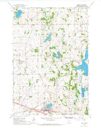 1965 Albany1966 Print · USGSStearns County is captured here in the mid-sixties, showcasing a landscape defined by small glacial lakes and a developing drainage network. Researchers can trace the Great Northern rail corridor through Albany or locate local landmarks like St Johns Cem and St. Anthony.2 unique versions available
 - 1965 Map of Farming, 1966 Print
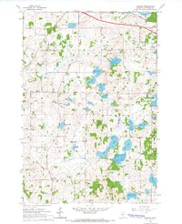 1965 Farming1966 Print · USGSStearns County in the mid-sixties reveals a landscape of family-named glacial lakes and a vanishing network of rural schoolhouses. Researchers can trace the Great Northern tracks and locate several community centers including Farming and Immanuel Ch.2 unique versions available
End of results
Showing maps 1-2 of 2
Top cities near Albany
- Cold Spring historical maps
- Melrose historical maps
- Rockville historical maps
- Avon historical maps
- Richmond historical maps
- Farming historical maps
See more
Top neighborhoods of Albany
Frequently asked questions
- What are the different types of historical maps available for Albany?
- What is the oldest map of Albany?
- Where can I purchase historical maps of Albany for my home or office?
- Where can I download high-res historical maps of Albany?
- Are there historical topographic maps available for Albany?
- Is there historical aerial imagery available for Albany?
- Where are historical maps of Albany sourced from?