1900s (20th Century) Maps of Waseca, Minnesota
Explore 7 historic maps of Waseca from the 1900s (20th Century). These maps offer a rare glimpse into what life looked like during the 1900s — showing old roads, neighborhoods, homes, and landmarks that have changed or disappeared over time.
Whether you're researching your family's past, planning a metal detecting trip, or studying how Waseca's landscape evolved across the 1900s, these high-resolution maps are a powerful tool for exploring the history of this region.
- Focus on a specific era: All maps on this page are from the 1900s, giving you a focused view of this time period.
- See what’s changed: Compare century-old streets, trails, and buildings to today's modern landscape using overlays and satellite layers.
- Research with precision: Use these maps for genealogy, historical research, land use analysis, or educational projects.
- View, download, or print: Maps are fully viewable online in high resolution, and can be downloaded or printed for your own records.
Start exploring Waseca's history through authentic maps from the 1900s. This is your window into the past.
Waseca, MN maps
(7)- 1953 Map of Saint Paul, 1964 Print
 1953 Saint Paul1964 Print · USGSThe Twin Cities and the Mississippi River valley are captured here at a mid-century turning point. Trace the early growth of Minneapolis and Saint Paul alongside landmarks like Lake Minnetonka and the St Croix River.4 unique versions available
 - 1959 Map of Saint Paul
 1959 Saint Paul1959 Print · USGSThe Twin Cities and southeastern Minnesota appear here in the late fifties, showing the peak of the rail era and post-war suburban growth. Genealogists can trace family footprints near Lake Minnetonka, the Univ Of Minn Rosemount Research Center, or the growing neighborhoods of Richfield.2 unique versions available
 - 1962 Map of Meriden, 1964 Print
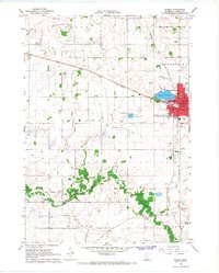
 1962 Meriden1964 Print · USGSWaseca and the surrounding farm townships are seen here in the early sixties, centered on the lakes and rail lines of south-central Minnesota. Genealogists can locate family landmarks like St Paul Ch, Karsten Cem, and rural schoolhouses such as School No 2142.
 - 1966 Map of Waseca, 1967 Print
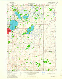
 1966 Waseca1967 Print · USGSMid-century Waseca County comes into focus here during a period of agricultural and institutional growth. Genealogists and local historians can trace the early city grid and rural parish life through sites like Loon Lake, the Southern School of Agriculture, and Wilton Cem.2 unique versions available
 - 1985 Map of Faribault, 1986 Print
 1985 Faribault1986 Print · USGSThe Minnesota River valley and the glacial lake country of Rice and Le Sueur counties are shown here in the mid-1980s. Researchers can trace the academic grounds of St Olaf College or find old crossroads like Trondhjem and Little Chicago.2 unique versions available
 - 1991 Map of Waseca, 1995 Print
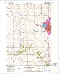 1991 Waseca1995 Print · USGSWaseca and the surrounding farm townships are seen here in the early 1990s as the regional agricultural and educational landscape evolved. Genealogists and local historians can locate several historic burial sites like Iosco Cem and St Marys Cem, or trace the Chicago and North Western rail line through town.
 - 1992 Map of Meriden, 1995 Print
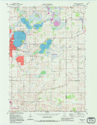 1992 Meriden1995 Print · USGSThe borderlands of Waseca and Steele Counties come to life in this late-century record of a lake-studded agricultural landscape. Genealogists can trace family roots through markers like Woodville Cem, St Paul Ch, and the rural School No 2098.
End of results
Showing maps 1-7 of 7
Top cities near Waseca
- Owatonna historical maps
- Faribault historical maps
- Janesville historical maps
- Waterville historical maps
- Warsaw historical maps
- New Richland historical maps
See more
Frequently asked questions
- What are the different types of historical maps available for Waseca?
- What is the oldest map of Waseca?
- Where can I purchase historical maps of Waseca for my home or office?
- Where can I download high-res historical maps of Waseca?
- Are there historical topographic maps available for Waseca?
- Is there historical aerial imagery available for Waseca?
- Where are historical maps of Waseca sourced from?