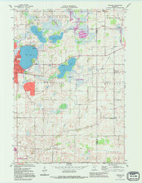
1992 Map of Meriden
USGS Topo · Published 1995About this map
The glacial landscape of the Waseca and Steele County line is defined by a dense network of prairie lakes and marshy wildlife reserves. On the western edge of the sheet, Waseca serves as the primary hub, surrounded by recreational and natural landmarks like Clear Lake and Rice Lake. The rural townships of Blooming Grove and Deerfield are dotted with small local institutions that speak to the area's pioneer heritage, including St Paul Ch and multiple rural schoolhouses such as School No 2142.
Find a feature on this map
28 named features on this map. Tap any name to fly to it.
Don’t see what you’re looking for? This feature index may not catch every label — zoom into the map to look around manually.
Map Details
Editions of this 1992 Meriden Map
This is the sole edition of this map. No revisions or reprints were ever made.
Other maps of this area

1953 · Saint Paul
USGS Topo · 1:250,000

1954 · Mason City
USGS Topo · 1:250,000

1957 · Mason City
USGS Topo · 1:250,000

1958 · Mason City
USGS Topo · 1:250,000

1959 · Saint Paul
USGS Topo · 1:250,000

1962 · Morristown
USGS Topo · 1:24,000

1962 · Saco
USGS Topo · 1:24,000

1962 · Meriden
USGS Topo · 1:24,000

1962 · Medford West
USGS Topo · 1:24,000

1966 · Waseca
USGS Topo · 1:24,000