1980s Maps of Winona, Minnesota
Explore 4 historic maps of Winona from the 1980s. These maps offer a rare glimpse into what life looked like during the 1980s — showing old roads, neighborhoods, homes, and landmarks that have changed or disappeared over time.
Whether you're researching your family's past, planning a metal detecting trip, or studying how Winona's landscape evolved across the 1980s, these high-resolution maps are a powerful tool for exploring the history of this region.
- Focus on a specific era: All maps on this page are from the 1980s, giving you a focused view of this time period.
- See what’s changed: Compare century-old streets, trails, and buildings to today's modern landscape using overlays and satellite layers.
- Research with precision: Use these maps for genealogy, historical research, land use analysis, or educational projects.
- View, download, or print: Maps are fully viewable online in high resolution, and can be downloaded or printed for your own records.
Start exploring Winona's history through authentic maps from the 1980s. This is your window into the past.
Winona, MN maps
(4)- 1980 Map of Witoka
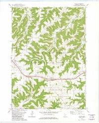 1980 Witoka1980 Print · USGSWinona County in the late seventies and early eighties shows a landscape shaped by narrow ridges and the corridor of the then-modern interstate. Genealogists can locate family sites at St. Patricks Cemetery, Cedar Valley Church, and the settlement of Witoka.2 unique versions available
 - 1980 Map of Wilson
 1980 Wilson1980 Print · USGSWinona County's wooded ridges and deep valleys are captured here in the late twentieth century, showing a landscape defined by state forestry and small rural communities. Researchers can trace family roots at Frank Hill Cem, St Johns Ch, and the settlement of Wilson.2 unique versions available
 - 1984 Map of La Crosse, 1985 Print
 1984 La Crosse1985 Print · USGSThe Driftless Area of the upper Mississippi valley appears here in the mid-eighties, showing the tri-state intersections of Wisconsin, Minnesota, and Iowa. Genealogists and local historians can trace family-named landmarks such as Peacock Ridge or Prosch Coulee and locate rural landmarks like St Marys Ch.
 - 1985 Map of Winona
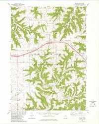
 1985 Winona1985 Print · USGSThe Mississippi River valley and the coulees of the Driftless Area are shown here in the mid-1980s as the river's lock-and-dam system was well-established. Researchers can trace the riverfront at Winona, explore the bluffs near Galesville, or locate landmarks like Sugarloaf and Merrick State Park.2 unique versions available
End of results
Showing maps 1-4 of 4
Top cities near Winona
- Arcadia historical maps
- Goodview historical maps
- Trempealeau historical maps
- Lewiston historical maps
- Homer historical maps
- Wilson historical maps
See more
Top neighborhoods of Winona
Frequently asked questions
- What are the different types of historical maps available for Winona?
- What is the oldest map of Winona?
- Where can I purchase historical maps of Winona for my home or office?
- Where can I download high-res historical maps of Winona?
- Are there historical topographic maps available for Winona?
- Is there historical aerial imagery available for Winona?
- Where are historical maps of Winona sourced from?