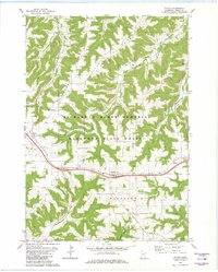
1980 Map of Witoka
USGS Topo · Published 1980About this map
Pleasant Ridge and Homer Ridge define the undulating landscape of Winona County in this 1980 survey, where deeply incised valleys like Pleasant Valley Creek and Homer Creek drain toward the northeast. The area is characterized by a mix of agriculture and conservation, with significant portions of the terrain protected within the Richard J Dorer Memorial Hardwood State Forest. Small rural settlements and intersections serve as local hubs, including Witoka and Ridgeway, the latter situated along the modern corridor of I-90. Local history and genealogy are anchored by several community landmarks, such as Cedar Valley Church and its associated cemetery, alongside St. Patricks Cemetery and Hillside Cemetery farther south. The map also records the location of industrial and infrastructure sites like the local Quarry and highway Weigh Stations.
Find a feature on this map
27 named features on this map. Tap any name to fly to it.
Don’t see what you’re looking for? This feature index may not catch every label — zoom into the map to look around manually.
Map Details
Editions of this 1980 Witoka Map
2 editions found
Other maps of this area

1929 · Fountain City
USGS Topo · 1:62,500

1929 · Galesville
USGS Topo · 1:62,500

1930 · La Crescent
USGS Topo · 1:62,500

1934 · Winona
USGS Topo · 1:62,500

1937 · Winona
USGS Topo · 1:62,500

1953 · Eau Claire
USGS Topo · 1:250,000

1956 · La Crescent
USGS Topo · 1:62,500

1958 · Eau Claire
USGS Topo · 1:250,000

1958 · Houston
USGS Topo · 1:62,500

1958 · La Crosse
USGS Topo · 1:250,000