1960s Maps of Natchez, Mississippi
Explore 3 historic maps of Natchez from the 1960s. These maps offer a rare glimpse into what life looked like during the 1960s — showing old roads, neighborhoods, homes, and landmarks that have changed or disappeared over time.
Whether you're researching your family's past, planning a metal detecting trip, or studying how Natchez's landscape evolved across the 1960s, these high-resolution maps are a powerful tool for exploring the history of this region.
- Focus on a specific era: All maps on this page are from the 1960s, giving you a focused view of this time period.
- See what’s changed: Compare century-old streets, trails, and buildings to today's modern landscape using overlays and satellite layers.
- Research with precision: Use these maps for genealogy, historical research, land use analysis, or educational projects.
- View, download, or print: Maps are fully viewable online in high resolution, and can be downloaded or printed for your own records.
Start exploring Natchez's history through authentic maps from the 1960s. This is your window into the past.
Natchez, MS maps
(3)- 1963 Map of Natchez, 1964 Print
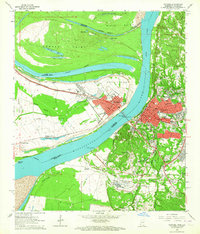 1963 Natchez1964 Print · USGSIn the early sixties, the riverfront at the Mississippi-Louisiana border was a hub of energy and rail transit. Researchers can trace historic properties like Whitehall Plantation, find small country churches like Pilgrim Ch, and locate active rail lines including the Illinois Central.3 unique versions available
 - 1963 Map of Washington, 1964 Print
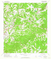 1963 Washington1964 Print · USGSAdams County in the early sixties reveals a landscape of deep-rooted settlements and military heritage east of the river. Genealogists and historians can trace family land via numerous burial sites like Foster Mound Cem and the grounds of Jefferson Military College.2 unique versions available
 - 1965 Map of Natchez, 1967 Print
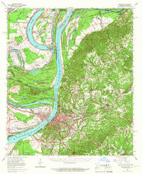 1965 Natchez1967 Print · USGSThe Mississippi River floodplain and the bluffs of Adams County are seen here in the mid-sixties, capturing a landscape of massive plantations and river engineering. Trace family sites at Hole in the Wall Plantation or Vidalia and locate landmarks like Jefferson Military College.2 unique versions available
End of results
Showing maps 1-3 of 3
Top cities near Natchez
Top neighborhoods of Natchez
Frequently asked questions
- What are the different types of historical maps available for Natchez?
- What is the oldest map of Natchez?
- Where can I purchase historical maps of Natchez for my home or office?
- Where can I download high-res historical maps of Natchez?
- Are there historical topographic maps available for Natchez?
- Is there historical aerial imagery available for Natchez?
- Where are historical maps of Natchez sourced from?