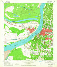
1963 Map of Natchez
USGS Topo · Published 1964About this map
Natchez, Mississippi, sits high on the bluffs overlooking the Mississippi River, showcasing its mid-century urban expansion alongside deep-rooted landmarks. This era reveals a dense network of local schools and institutions, from the Natchez Jr College to the National Cem and the expansive City Cemetery. Across the water in Louisiana, the town of Vidalia is protected by an extensive levee system, with the Missouri Pacific railroad corridor cutting through the landscape toward Minorca and Taconey.
Find a feature on this map
86 named features on this map. Tap any name to fly to it.
Don’t see what you’re looking for? This feature index may not catch every label — zoom into the map to look around manually.
Map Details
Editions of this 1963 Natchez Map
3 editions found
Other maps of this area

1909 · Sycamore Landing
USGS Topo · 1:24,000

1909 · Vidalia
USGS Topo · 1:24,000

1921 · Natchez
USGS Topo · 1:48,000

1922 · Natchez
USGS Topo · 1:62,500

1939 · Red Gum
USGS Topo · 1:62,500

1939 · Natchez
USGS Topo · 1:62,500

1939 · Kingston
USGS Topo · 1:62,500

1939 · Deer Park
USGS Topo · 1:62,500

1953 · Natchez
USGS Topo · 1:250,000

1956 · Natchez
USGS Topo · 1:250,000