1970s Maps of Slate Springs, Mississippi
Explore 2 historic maps of Slate Springs from the 1970s. These maps offer a rare glimpse into what life looked like during the 1970s — showing old roads, neighborhoods, homes, and landmarks that have changed or disappeared over time.
Whether you're researching your family's past, planning a metal detecting trip, or studying how Slate Springs's landscape evolved across the 1970s, these high-resolution maps are a powerful tool for exploring the history of this region.
- Focus on a specific era: All maps on this page are from the 1970s, giving you a focused view of this time period.
- See what’s changed: Compare century-old streets, trails, and buildings to today's modern landscape using overlays and satellite layers.
- Research with precision: Use these maps for genealogy, historical research, land use analysis, or educational projects.
- View, download, or print: Maps are fully viewable online in high resolution, and can be downloaded or printed for your own records.
Start exploring Slate Springs's history through authentic maps from the 1970s. This is your window into the past.
Slate Springs, MS maps
(2)- 1976 Map of Pittsboro SE, 1977 Print
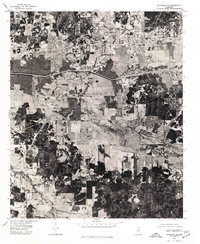 1976 Pittsboro SE1977 Print · USGSCalhoun County in the mid-seventies is seen here through detailed aerial photography, showing the rural landscape around Calhoun City. Researchers can trace land use patterns and water management systems like the Yalobusha Canal and the town grid of Derma.
 - 1976 Map of Walthall NE, 1977 Print
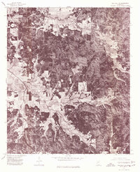 1976 Walthall NE1977 Print · USGSWebster County’s rural landscape is revealed through mid-seventies aerial imagery, documenting the timberlands and homesteads of northern Mississippi. Researchers can locate exact building footprints and property clearings near Bellefontaine, Slate Spring, and Embry.
End of results
Showing maps 1-2 of 2
Top cities near Slate Springs
- Eupora historical maps
- Calhoun City historical maps
- Derma historical maps
- Vardaman historical maps
- Pittsboro historical maps
- Walthall historical maps
See more
Frequently asked questions
- What are the different types of historical maps available for Slate Springs?
- What is the oldest map of Slate Springs?
- Where can I purchase historical maps of Slate Springs for my home or office?
- Where can I download high-res historical maps of Slate Springs?
- Are there historical topographic maps available for Slate Springs?
- Is there historical aerial imagery available for Slate Springs?
- Where are historical maps of Slate Springs sourced from?