1980s Maps of Slate Springs, Mississippi
Explore 6 historic maps of Slate Springs from the 1980s. These maps offer a rare glimpse into what life looked like during the 1980s — showing old roads, neighborhoods, homes, and landmarks that have changed or disappeared over time.
Whether you're researching your family's past, planning a metal detecting trip, or studying how Slate Springs's landscape evolved across the 1980s, these high-resolution maps are a powerful tool for exploring the history of this region.
- Focus on a specific era: All maps on this page are from the 1980s, giving you a focused view of this time period.
- See what’s changed: Compare century-old streets, trails, and buildings to today's modern landscape using overlays and satellite layers.
- Research with precision: Use these maps for genealogy, historical research, land use analysis, or educational projects.
- View, download, or print: Maps are fully viewable online in high resolution, and can be downloaded or printed for your own records.
Start exploring Slate Springs's history through authentic maps from the 1980s. This is your window into the past.
Slate Springs, MS maps
(6)- 1983 Map of Cadaretta, 1984 Print
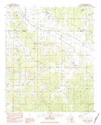 1983 Cadaretta1984 Print · USGSNorth Mississippi's rural communities at the Calhoun and Webster County line are captured here in the early eighties. Genealogists can trace family footprints at Old Salem Cem and Pittman Cem or locate the rural pulpits of Philadelphia Ch and Embry Ch.
 - 1983 Map of Bellefontaine, 1984 Print
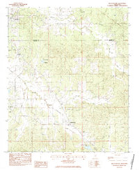 1983 Bellefontaine1984 Print · USGSThe Webster and Calhoun County borderlands are captured here in the early eighties, still defined by the historic Old Indian Treaty Boundary. Genealogists can trace family names at Vance Cem, Spencer Cem, and the community surrounding Slate Spring.
 - 1983 Map of Calhoun City, 1984 Print
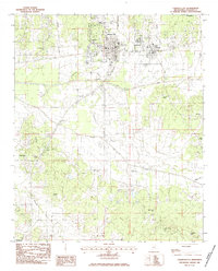 1983 Calhoun City1984 Print · USGSCalhoun County in the early eighties shows a landscape shaped by ancient borders and river networks. Researchers can trace the Old Indian Treaty Boundary near Calhoun City or locate family history at Cross Road Cem and Benele Cem.
 - 1983 Map of Big Creek, 1984 Print
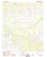 1983 Big Creek1984 Print · USGSCalhoun County in the early eighties was defined by its winding waterways and managed wilderness areas. Researchers can trace the Indian Treaty Boundary Line or locate family roots near Sabougla, Magness Cem, and Chapel Hill Ch.
 - 1984 Map of West Point
 1984 West Point1984 Print · USGSNorth-Central Mississippi in the mid-eighties shows a landscape defined by massive water management projects and dense timberlands. Researchers can trace the legacy of rural settlements like Geeslin Corner or the rail corridors of the Illinois Central Gulf RR near Grenada Lake.3 unique versions available
 - 1984 Map of Grenada, 1990 Print
 1984 Grenada1990 Print · USGSNorth Central Mississippi’s river valleys and conservation lands are captured here in the mid-1980s. Researchers can trace the sprawling Camp Mc Cain, the Illinois Central Gulf rail line, and the historic Treaty Boundary.
End of results
Showing maps 1-6 of 6
Top cities near Slate Springs
- Eupora historical maps
- Calhoun City historical maps
- Derma historical maps
- Vardaman historical maps
- Pittsboro historical maps
- Walthall historical maps
See more
Frequently asked questions
- What are the different types of historical maps available for Slate Springs?
- What is the oldest map of Slate Springs?
- Where can I purchase historical maps of Slate Springs for my home or office?
- Where can I download high-res historical maps of Slate Springs?
- Are there historical topographic maps available for Slate Springs?
- Is there historical aerial imagery available for Slate Springs?
- Where are historical maps of Slate Springs sourced from?