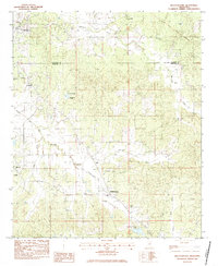
1983 Map of Bellefontaine
USGS Topo · Published 1984About this map
Slate Spring and the surrounding Webster and Calhoun County hill country are defined by a network of rural churches and family cemeteries in this early 1980s study. The landscape is bisected by the Old Indian Treaty Boundary, a significant historical line marking earlier land divisions that still influenced property and jurisdictional boundaries into the modern era. Small community hubs like Bellefontaine and Embry serve as focal points for local navigation, connected by roads that wind past landmarks such as Dorroh Lake Chapel and North Union Ch. The drainage patterns are dominated by the Sabougla Creek Canal (Left) and Shutispear Creek, illustrating the management of the region's water resources. Genealogists will find particular value in the numerous burial sites identified, including Zion Cem, Vance Cem, and Quinn Cem.
Find a feature on this map
25 named features on this map. Tap any name to fly to it.
Don’t see what you’re looking for? This feature index may not catch every label — zoom into the map to look around manually.
Map Details
Editions of this 1983 Bellefontaine Map
This is the sole edition of this map. No revisions or reprints were ever made.
Other maps of this area

1953 · Walthall
USGS Topo · 1:62,500

1953 · West Point
USGS Topo · 1:250,000

1954 · Pittsboro
USGS Topo · 1:62,500

1958 · West Point
USGS Topo · 1:250,000

1963 · West Point
USGS Topo · 1:250,000

1972 · Atlanta
USGS Topo · 1:24,000

1972 · Sapa
USGS Topo · 1:24,000

1972 · Hohenlinden
USGS Topo · 1:24,000
1976 · Pittsboro SE
USGS Topo · 1:24,000
1976 · Walthall SE
USGS Topo · 1:24,000