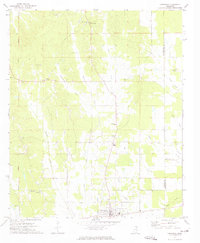
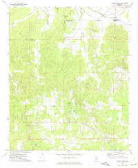
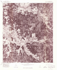
1976 Map of Pittsboro SE
USGS Topo · Published 1977About this map
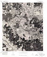
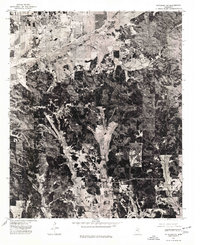
Calhoun City and its neighbor Derma stand as the primary population centers in this mid-1970s orthophoto quadrangle. Unlike a traditional topographic map, this aerial perspective reveals the precise textures of the Mississippi landscape, showing the dense patchwork of agricultural fields and timbered tracts. The defining engineering features of the area are the massive drainage projects, most notably the Yalobusha Canal which cuts a straight, unnatural line across the terrain to manage the region's water. Further south, the meandering path of the original watercourse is superseded by the Topashaw Creek Canal. These artificial waterways illustrate the 20th-century effort to reclaim and protect the bottomlands for farming, showing how the natural hydrology of Calhoun County was reshaped by significant earth-moving projects.
Find a feature on this map
4 named features on this map. Tap any name to fly to it.
Don’t see what you’re looking for? This feature index may not catch every label — zoom into the map to look around manually.
Map Details
Editions of this 1976 Pittsboro SE Map
This is the sole edition of this map. No revisions or reprints were ever made.
Other maps of this area
1953 · Walthall
USGS Topo · 1:62,500

1953 · West Point
USGS Topo · 1:250,000
1954 · Pittsboro
USGS Topo · 1:62,500

1958 · West Point
USGS Topo · 1:250,000

1963 · West Point
USGS Topo · 1:250,000
1972 · Atlanta
USGS Topo · 1:24,000
1972 · Vardaman
USGS Topo · 1:24,000
1972 · Hohenlinden
USGS Topo · 1:24,000
1976 · Pittsboro NE
USGS Topo · 1:24,000
1976 · Walthall NE
USGS Topo · 1:24,000