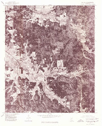
1976 Map of Walthall NE
USGS Topo · Published 1977About this map
Bellefontaine and Slate Spring anchor the corners of this 1976 orthophotoquad, which provides a direct visual record of the land use and timber patterns in northern Mississippi. Unlike traditional line-drawn maps, this aerial imagery reveals the exact texture of the landscape, from the winding path of Sabougia Creek to the intricate patchworking of clearings and wooded parcels. Small rural crossroads such as Embry and Shumispear appear as clusters of structures amidst the heavy canopy, offering genealogists and land researchers a precise look at homestead placements and road networks in this part of Webster County during the mid-1970s. The map captures the region at a time when traditional agriculture and forestry dictated the local economy and settlement footprint.
Find a feature on this map
5 named features on this map. Tap any name to fly to it.
Don’t see what you’re looking for? This feature index may not catch every label — zoom into the map to look around manually.
Map Details
Editions of this 1976 Walthall NE Map
This is the sole edition of this map. No revisions or reprints were ever made.
Other maps of this area

1953 · Walthall
USGS Topo · 1:62,500

1953 · West Point
USGS Topo · 1:250,000

1954 · Pittsboro
USGS Topo · 1:62,500

1958 · West Point
USGS Topo · 1:250,000

1963 · West Point
USGS Topo · 1:250,000

1972 · Atlanta
USGS Topo · 1:24,000

1972 · Sapa
USGS Topo · 1:24,000

1972 · Hohenlinden
USGS Topo · 1:24,000
1976 · Pittsboro SE
USGS Topo · 1:24,000
1976 · Walthall SE
USGS Topo · 1:24,000