1970s Maps of Wiltshire, Mississippi
Explore 2 historic maps of Wiltshire from the 1970s. These maps offer a rare glimpse into what life looked like during the 1970s — showing old roads, neighborhoods, homes, and landmarks that have changed or disappeared over time.
Whether you're researching your family's past, planning a metal detecting trip, or studying how Wiltshire's landscape evolved across the 1970s, these high-resolution maps are a powerful tool for exploring the history of this region.
- Focus on a specific era: All maps on this page are from the 1970s, giving you a focused view of this time period.
- See what’s changed: Compare century-old streets, trails, and buildings to today's modern landscape using overlays and satellite layers.
- Research with precision: Use these maps for genealogy, historical research, land use analysis, or educational projects.
- View, download, or print: Maps are fully viewable online in high resolution, and can be downloaded or printed for your own records.
Start exploring Wiltshire's history through authentic maps from the 1970s. This is your window into the past.
Wiltshire, MS maps
(2)- 1975 Map of Peachahala Creek, 1978 Print
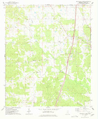 1975 Peachahala Creek1978 Print · USGSCarroll County's rolling landscape and rural settlements are frozen in time during the mid-seventies. Researchers can trace family history through several local landmarks like Hairston Cem, Lively Stone Ch, and the community at Hocutt.
 - 1978 Map of Coila
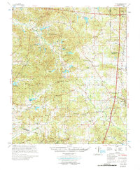 1978 Coila1978 Print · USGSCentral Mississippi in the late seventies is shown here as a landscape of crossroads communities and historic treaty boundaries. Researchers can trace family roots through numerous rural landmarks like Hopewell Cem, St Johns Chapel, and the small settlement of Coila.
End of results
Showing maps 1-2 of 2
Top cities near Wiltshire
- Winona historical maps
- Durant historical maps
- Lexington historical maps
- Vaiden historical maps
- North Carrollton historical maps
- Carrollton historical maps
See more
Frequently asked questions
- What are the different types of historical maps available for Wiltshire?
- What is the oldest map of Wiltshire?
- Where can I purchase historical maps of Wiltshire for my home or office?
- Where can I download high-res historical maps of Wiltshire?
- Are there historical topographic maps available for Wiltshire?
- Is there historical aerial imagery available for Wiltshire?
- Where are historical maps of Wiltshire sourced from?