1900s (20th Century) Maps of Clay County, Mississippi
Explore 26 historic maps of Clay County from the 1900s (20th Century). These maps offer a rare glimpse into what life looked like during the 1900s — showing old roads, neighborhoods, homes, and landmarks that have changed or disappeared over time.
Whether you're researching your family's past, planning a metal detecting trip, or studying how Clay County's landscape evolved across the 1900s, these high-resolution maps are a powerful tool for exploring the history of this region.
- Focus on a specific era: All maps on this page are from the 1900s, giving you a focused view of this time period.
- See what’s changed: Compare century-old streets, trails, and buildings to today's modern landscape using overlays and satellite layers.
- Research with precision: Use these maps for genealogy, historical research, land use analysis, or educational projects.
- View, download, or print: Maps are fully viewable online in high resolution, and can be downloaded or printed for your own records.
Start exploring Clay County's history through authentic maps from the 1900s. This is your window into the past.
Clay County, MS maps
(26)- 1953 Map of West Point, 1973 Print
 1953 West Point1973 Print · USGSNorth-Central Mississippi and the Alabama borderlands are captured here during the mid-twentieth century as new reservoirs and national forests transformed the landscape. Researchers can trace the path of the Mississippi & Skuna Valley railroad or locate old landings along the Tombigbee River and Schooner Creek.3 unique versions available
 - 1958 Map of West Point
 1958 West Point1958 Print · USGSNortheastern Mississippi and western Alabama are shown in the late 1950s, highlighting a region defined by its river-and-rail economy. Researchers can trace family roots through numerous settlements like Artesia and Vardaman or explore the corridor of the Tombigbee River.
 - 1959 Map of West Point, 1960 Print
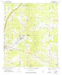
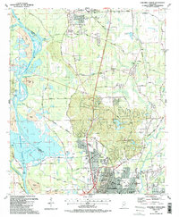
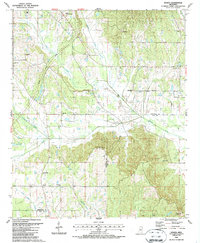
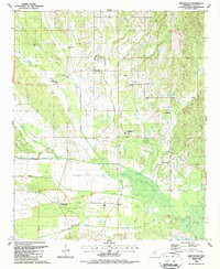
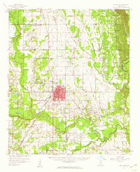 1959 West Point1960 Print · USGSClay County and the surrounding Black Prairie region appear here in the late fifties, centered on the rail junction at West Point. Researchers can trace rural lineages through numerous family-named landmarks and local sites like Holmes Jr College, Sandy Clay Sch, and the Town Creek Ch Cem.3 unique versions available
 - 1959 Map of Van Vleet, 1960 Print
 1959 Van Vleet1960 Print · USGSChickasaw and Clay Counties are shown here in the late fifties as the modern Natchez Trace Parkway was first being cut through the hills. Genealogists can locate dozens of rural landmarks, from Witch Dance Hill to the Asbury Cem and New Zion Sch.3 unique versions available
 - 1959 Map of Pheba, 1960 Print
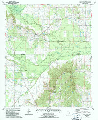
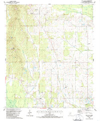
 1959 Pheba1960 Print · USGSClay County in the late fifties shows a rural landscape stitched together by country schools and small crossroads. Genealogists can trace family lines through Pearsons Chapel Cem or locate community hubs like Beasley High Sch and the Old Indian Boundary.
 - 1960 Map of Caledonia, 1961 Print
 1960 Caledonia1961 Print · USGSThe Mississippi-Alabama borderlands in the early sixties reveal a landscape of growing military bases and traditional river commerce. Trace family roots through rural landmarks like Anderson Grove Sch, Waverly Ferry, and the rail lines serving Steens.2 unique versions available
 - 1963 Map of West Point
 1963 West Point1963 Print · USGSEastern Mississippi and western Alabama are captured in the early sixties as industrial centers and rail lines connected the Black Prairie to the hills. Genealogists and historians can trace family-named watercourses and the early footprints of Starkville, Columbus, and the Noxubee National Wildlife Refuge.2 unique versions available
 - 1966 Map of Prairie, 1967 Print
 1966 Prairie1967 Print · USGSNortheastern Mississippi comes alive in the mid-1960s as a land of rural churches and rail-side hamlets. Researchers can trace the GULF MOBILE AND OHIO railroad line through Prairie and locate family landmarks like Patterson Cem and Ebenezer Ch.2 unique versions available
 - 1972 Map of Maben, 1974 Print
 1972 Maben1974 Print · USGSMaben and Mathiston appear as active rail-and-road junctions in the early seventies, positioned at the convergence of four North Mississippi counties. Local historians can trace old community centers like Cumberland, dozens of country churches including Double Springs Ch, and the route of the Natchez Trace Parkway.
 - 1972 Map of Mantee, 1974 Print
 1972 Mantee1974 Print · USGSWebster County in the early 1970s reveals a rural landscape defined by the Natchez Trace Parkway and historic rail corridors. Researchers can locate community centers like Mantee and Dancy, or trace family sites at Wake Forest Ch and Mount Pleasant Cem.
 - 1972 Map of Woodland, 1974 Print
 1972 Woodland1974 Print · USGSChickasaw and Clay counties come together in this early 1970s study of the rural landscape around the village of Woodland. Researchers can trace the path of the Natchez Trace Parkway and locate several community anchors like Rhodes Chapel, Tabbville, and Woodland Cem.
 - 1982 Map of West Point, 1983 Print
 1982 West Point1983 Print · USGSEastern Mississippi and western Alabama are captured in the early eighties as the river-and-rail economy evolved. Trace family roots and old township lines near West Point, Columbus Air Force Base, and the historic Natchez Trace Parkway.
 - 1984 Map of West Point
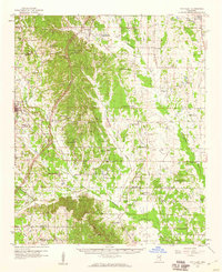
 1984 West Point1984 Print · USGSNorth-Central Mississippi in the mid-eighties shows a landscape defined by massive water management projects and dense timberlands. Researchers can trace the legacy of rural settlements like Geeslin Corner or the rail corridors of the Illinois Central Gulf RR near Grenada Lake.3 unique versions available
 - 1984 Map of Grenada, 1990 Print
 1984 Grenada1990 Print · USGSNorth Central Mississippi’s river valleys and conservation lands are captured here in the mid-1980s. Researchers can trace the sprawling Camp Mc Cain, the Illinois Central Gulf rail line, and the historic Treaty Boundary.
 - 1987 Map of Hamilton
 1987 Hamilton1987 Print · USGSThe Monroe and Lowndes County line in the late eighties shows a landscape of military aviation and river engineering. Trace the boundaries of Columbus Air Force Base or locate rural landmarks like Sardis Cem and Sulphur Springs Sch.
 - 1987 Map of Columbus North
 1987 Columbus North1987 Print · USGSNorthern Mississippi in the late eighties shows the rise of major water projects and military infrastructure. Trace the early layout of Columbus near the Columbus Air Force Base and historic churches like Antioch Ch.2 unique versions available
 - 1987 Map of Cedar Bluff
 1987 Cedar Bluff1987 Print · USGSClay and Oktibbeha Counties come together in the late eighties along a network of creek bottoms and rail lines. Genealogists can trace family names at Cumberland Cem and Mosley Cem or locate rural centers like Cedar Bluff and St Pauls Ch.
 - 1987 Map of West Point
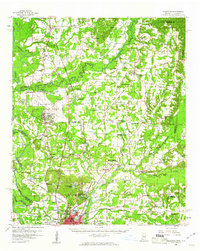
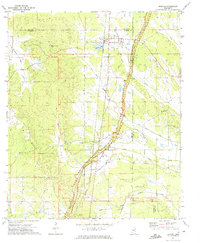
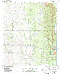
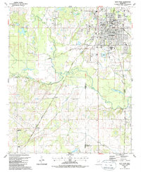 1987 West Point1987 Print · USGSWest Point and the surrounding river bottoms of Clay County appear here in the late eighties during a period of steady growth. Genealogists can trace family landmarks and local institutions from Lindsey Chapel and Muldrow to the sprawling grounds of Greenwood Cem.
 - 1987 Map of Waverly
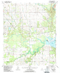 1987 Waverly1987 Print · USGSThe rural borderlands of Clay and Lowndes counties are captured here in the late eighties, just north of the recently formed Columbus Lake. Genealogists and local historians can trace family ties through Tibbee Cem, Lee Cem, and several country churches like Shady Grove Ch.
 - 1987 Map of Sparta
 1987 Sparta1987 Print · USGSThe rural borderlands of Chickasaw and Clay Counties are shown in the late 1980s as agricultural life continues alongside the Natchez Trace Parkway. Genealogists can locate family landmarks like Hughes Cem, Oak Grove Cem, and New Zion Ch.
 - 1987 Map of Strong
 1987 Strong1987 Print · USGSThe Tombigbee River valley in the late eighties shows a landscape of traditional settlements and modern engineering projects. Genealogists can trace family sites like Strong Cem and Mt Zion Ch alongside the newly formed Columbus Lake.
 - 1987 Map of Pheba
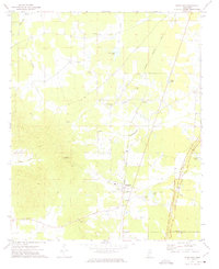
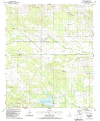 1987 Pheba1987 Print · USGSPheba and the surrounding Clay County countryside are shown here in the late 1980s. Local researchers can trace rural life through sites like Hebron Sch, Mt Zion Ch, and the COLUMBUS AND GREENVILLE rail line.
 - 1987 Map of Trebloc
 1987 Trebloc1987 Print · USGSChickasaw and Clay County lands are shown in the late 1980s, documenting a landscape of rural hamlets and creek-side cemeteries. Genealogists can locate Trebloc, McCondy, and family landmarks like Thornton Cem or Macedonia Ch.
 - 1987 Map of Montpelier
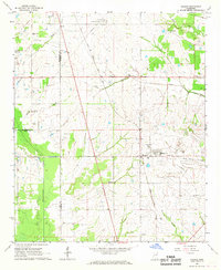
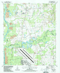
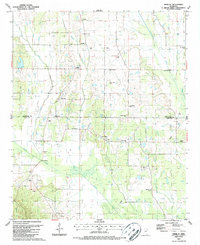
 1987 Montpelier1987 Print · USGSClay County, Mississippi, is shown here in the late twentieth century as a landscape shaped by creek systems and early treaty lines. Genealogists and historians can trace local community roots through family-named sites like Walkers Gin and the Old Indian Treaty Boundary.
 - 1987 Map of Palo Alto
 1987 Palo Alto1987 Print · USGSClay County's rural character is preserved here as it appeared in the late eighties, featuring a dense network of family-named settlements and country churches. Genealogists can trace local heritage through landmarks like Palo Alto, Siloam, and the St Robertson Cem.
Showing maps 1-25 of 26
Top cities of Clay County
Frequently asked questions
- What are the different types of historical maps available for Clay County?
- What is the oldest map of Clay County?
- Where can I purchase historical maps of Clay County for my home or office?
- Where can I download high-res historical maps of Clay County?
- Are there historical topographic maps available for Clay County?
- Is there historical aerial imagery available for Clay County?
- Where are historical maps of Clay County sourced from?