1970s Maps of Clay County, Mississippi
Explore 3 historic maps of Clay County from the 1970s. These maps offer a rare glimpse into what life looked like during the 1970s — showing old roads, neighborhoods, homes, and landmarks that have changed or disappeared over time.
Whether you're researching your family's past, planning a metal detecting trip, or studying how Clay County's landscape evolved across the 1970s, these high-resolution maps are a powerful tool for exploring the history of this region.
- Focus on a specific era: All maps on this page are from the 1970s, giving you a focused view of this time period.
- See what’s changed: Compare century-old streets, trails, and buildings to today's modern landscape using overlays and satellite layers.
- Research with precision: Use these maps for genealogy, historical research, land use analysis, or educational projects.
- View, download, or print: Maps are fully viewable online in high resolution, and can be downloaded or printed for your own records.
Start exploring Clay County's history through authentic maps from the 1970s. This is your window into the past.
Clay County, MS maps
(3)- 1972 Map of Maben, 1974 Print
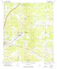 1972 Maben1974 Print · USGSMaben and Mathiston appear as active rail-and-road junctions in the early seventies, positioned at the convergence of four North Mississippi counties. Local historians can trace old community centers like Cumberland, dozens of country churches including Double Springs Ch, and the route of the Natchez Trace Parkway.
 - 1972 Map of Mantee, 1974 Print
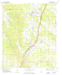 1972 Mantee1974 Print · USGSWebster County in the early 1970s reveals a rural landscape defined by the Natchez Trace Parkway and historic rail corridors. Researchers can locate community centers like Mantee and Dancy, or trace family sites at Wake Forest Ch and Mount Pleasant Cem.
 - 1972 Map of Woodland, 1974 Print
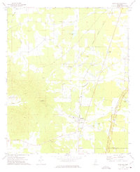 1972 Woodland1974 Print · USGSChickasaw and Clay counties come together in this early 1970s study of the rural landscape around the village of Woodland. Researchers can trace the path of the Natchez Trace Parkway and locate several community anchors like Rhodes Chapel, Tabbville, and Woodland Cem.
End of results
Showing maps 1-3 of 3
Top cities of Clay County
Frequently asked questions
- What are the different types of historical maps available for Clay County?
- What is the oldest map of Clay County?
- Where can I purchase historical maps of Clay County for my home or office?
- Where can I download high-res historical maps of Clay County?
- Are there historical topographic maps available for Clay County?
- Is there historical aerial imagery available for Clay County?
- Where are historical maps of Clay County sourced from?