1910s Maps of Coahoma County, Mississippi
Explore 4 historic maps of Coahoma County from the 1910s. These maps offer a rare glimpse into what life looked like during the 1910s — showing old roads, neighborhoods, homes, and landmarks that have changed or disappeared over time.
Whether you're researching your family's past, planning a metal detecting trip, or studying how Coahoma County's landscape evolved across the 1910s, these high-resolution maps are a powerful tool for exploring the history of this region.
- Focus on a specific era: All maps on this page are from the 1910s, giving you a focused view of this time period.
- See what’s changed: Compare century-old streets, trails, and buildings to today's modern landscape using overlays and satellite layers.
- Research with precision: Use these maps for genealogy, historical research, land use analysis, or educational projects.
- View, download, or print: Maps are fully viewable online in high resolution, and can be downloaded or printed for your own records.
Start exploring Coahoma County's history through authentic maps from the 1910s. This is your window into the past.
Coahoma County, MS maps
(4)- 1910 Map of Coahoma
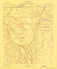 1910 Coahoma1910 Print · USGSCoahoma County at the start of the twentieth century was a landscape of winding bayous and expanding rail lines. Genealogists and historians can trace the foundations of local commerce at Coahoma, King & Anderson's, and along the Sheriff Ridge Road.
 - 1910 Map of Jonestown
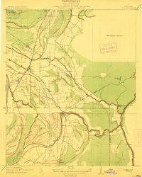
 1910 Jonestown1910 Print · USGSCoahoma and Quitman counties appear here in the early twentieth century as a landscape of winding oxbow lakes and essential rail lines. Genealogists and historians can trace local life through rural landmarks like Hopewell Church, the settlement at Eagles Nest, and the Yazoo and Mississippi Valley RR.
 - 1912 Map of Moon Lake
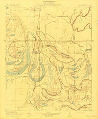
 1912 Moon Lake1912 Print · USGSThe Mississippi Delta's intricate river-and-rail landscape is preserved here during the early twentieth century. Genealogists and local historians can trace the foundations of the area through the Yazoo and Mississippi Valley R R and rural settlements like Powell and Delta Gerald P O.3 unique versions available
 - 1912 Map of Lula
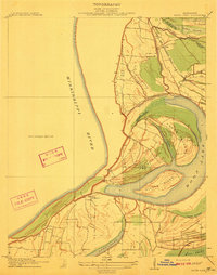
 1912 Lula1912 Print · USGSThe Mississippi Delta at the start of the twentieth century shows a landscape defined by lumber rails and oxbow lakes. Trace the early growth of Lula and Rich along the Yazoo and Mississippi Valley R. R. and the winding Yazoo Pass.
End of results
Showing maps 1-4 of 4
Top cities of Coahoma County
- Clarksdale historical maps
- Jonestown historical maps
- Friars Point historical maps
- Lyon historical maps
- Coahoma historical maps
- Lula historical maps
Frequently asked questions
- What are the different types of historical maps available for Coahoma County?
- What is the oldest map of Coahoma County?
- Where can I purchase historical maps of Coahoma County for my home or office?
- Where can I download high-res historical maps of Coahoma County?
- Are there historical topographic maps available for Coahoma County?
- Is there historical aerial imagery available for Coahoma County?
- Where are historical maps of Coahoma County sourced from?