1960s Maps of Hazlehurst, Mississippi
Explore 4 historic maps of Hazlehurst from the 1960s. These maps offer a rare glimpse into what life looked like during the 1960s — showing old roads, neighborhoods, homes, and landmarks that have changed or disappeared over time.
Whether you're researching your family's past, planning a metal detecting trip, or studying how Hazlehurst's landscape evolved across the 1960s, these high-resolution maps are a powerful tool for exploring the history of this region.
- Focus on a specific era: All maps on this page are from the 1960s, giving you a focused view of this time period.
- See what’s changed: Compare century-old streets, trails, and buildings to today's modern landscape using overlays and satellite layers.
- Research with precision: Use these maps for genealogy, historical research, land use analysis, or educational projects.
- View, download, or print: Maps are fully viewable online in high resolution, and can be downloaded or printed for your own records.
Start exploring Hazlehurst's history through authentic maps from the 1960s. This is your window into the past.
Hazlehurst, MS maps
(4)- 1963 Map of Crystal Springs, 1964 Print
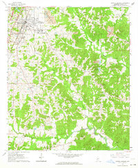 1963 Crystal Springs1964 Print · USGSMid-century Copiah County comes to life as a hub for sand and gravel extraction and rail transport along the Gulf Mobile and Ohio. Genealogists can locate family landmarks such as Holtzclaw Sch, Poplar Springs Cem, and the Red Barn Ch.2 unique versions available
 - 1963 Map of Gallman, 1964 Print
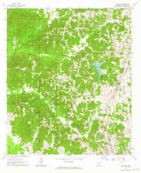 1963 Gallman1964 Print · USGSThe rural landscape of Copiah County is documented here during the early sixties, centered on the railroad community of Gallman. Local historians can trace family roots through the many rural churches and cemeteries, including New Pisgah Ch, Alford Cem, and the waters of Lake Copiah.3 unique versions available
 - 1963 Map of Hazlehurst, 1964 Print
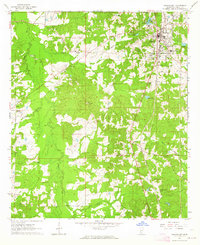 1963 Hazlehurst1964 Print · USGSHazlehurst and the surrounding Copiah County hill country are captured here in the early sixties, centered on the vital Illinois Central rail line. Family historians can trace deep roots through local landmarks like Martinsville, Antioch Ch, and the Pleasant Grove Ch & Cem.2 unique versions available
 - 1963 Map of Shady Grove, 1964 Print
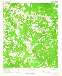 1963 Shady Grove1964 Print · USGSThe rural pine woods of Copiah County are captured here in the early sixties as small farming communities and timberlands defined the area. Genealogists and local historians can trace family-named sites like Russell-Tillman Cem, Shady Grove, and Sardis Ch.2 unique versions available
End of results
Showing maps 1-4 of 4
Top cities near Hazlehurst
- Crystal Springs historical maps
- Wesson historical maps
- Georgetown historical maps
- Beauregard historical maps
Frequently asked questions
- What are the different types of historical maps available for Hazlehurst?
- What is the oldest map of Hazlehurst?
- Where can I purchase historical maps of Hazlehurst for my home or office?
- Where can I download high-res historical maps of Hazlehurst?
- Are there historical topographic maps available for Hazlehurst?
- Is there historical aerial imagery available for Hazlehurst?
- Where are historical maps of Hazlehurst sourced from?