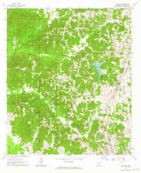
1963 Map of Gallman
USGS Topo · Published 1964About this map
Gallman serves as the primary rail-side hub for this portion of Copiah County in the early 1960s, situated along the Illinois Central railroad. The landscape is heavily defined by its drainage network, with Turkey Creek and Long Creek cutting through the terrain towards Bayou Pierre in the southwest. A notable localized development is Lake Copiah, which provides a focal point for recreation and community activity, evidenced by the nearby Camp Wesley Pines.
Find a feature on this map
31 named features on this map. Tap any name to fly to it.
Don’t see what you’re looking for? This feature index may not catch every label — zoom into the map to look around manually.
Map Details
Editions of this 1963 Gallman Map
3 editions found
Other maps of this area

1903 · Jackson
USGS Topo · 1:125,000

1937 · Terry
USGS Topo · 1:48,000

1943 · Terry
USGS Topo · 1:62,500

1953 · Natchez
USGS Topo · 1:250,000

1955 · Jackson
USGS Topo · 1:250,000

1956 · Natchez
USGS Topo · 1:250,000

1959 · Natchez
USGS Topo · 1:250,000

1961 · Jackson
USGS Topo · 1:250,000

1962 · Jackson
USGS Topo · 1:250,000

1963 · Dentville
USGS Topo · 1:24,000