1950s Maps of Diamondhead, Mississippi
Explore 6 historic maps of Diamondhead from the 1950s. These maps offer a rare glimpse into what life looked like during the 1950s — showing old roads, neighborhoods, homes, and landmarks that have changed or disappeared over time.
Whether you're researching your family's past, planning a metal detecting trip, or studying how Diamondhead's landscape evolved across the 1950s, these high-resolution maps are a powerful tool for exploring the history of this region.
- Focus on a specific era: All maps on this page are from the 1950s, giving you a focused view of this time period.
- See what’s changed: Compare century-old streets, trails, and buildings to today's modern landscape using overlays and satellite layers.
- Research with precision: Use these maps for genealogy, historical research, land use analysis, or educational projects.
- View, download, or print: Maps are fully viewable online in high resolution, and can be downloaded or printed for your own records.
Start exploring Diamondhead's history through authentic maps from the 1950s. This is your window into the past.
Diamondhead, MS maps
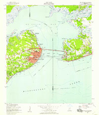
(6)- 1953 Map of Mobile, 1968 Print
 1953 Mobile1968 Print · USGSThe Gulf Coast comes alive in this mid-century survey, from the streets of Mobile to the marshes of New Orleans. Trace family roots in coastal towns like Pass Christian and Bayou La Batre or locate military landmarks including Keesler AFB.3 unique versions available
 - 1956 Map of Bay St. Louis, 1958 Print
 1956 Bay St. Louis1958 Print · USGSThe Mississippi Gulf Coast is captured here in the mid-fifties, showing the vital rail and road links across St Louis Bay. Researchers can locate family landmarks like the Widow Morin Claim or historic institutions such as St Stanislaus College.5 unique versions available
 - 1956 Map of Vidalia, 1960 Print
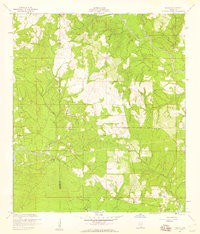 1956 Vidalia1960 Print · USGSCoastal Harrison County and the bayou country come into focus during the mid-fifties as rural settlements like Vidalia and De Lisle remained centered on timber and tide. Genealogists can trace family landmarks like Sand Hill Cem, St Joseph Ch, and St Stephens Sch.5 unique versions available
 - 1956 Map of Waveland, 1960 Print
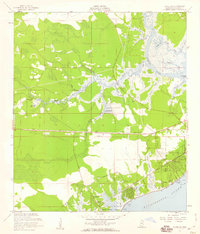 1956 Waveland1960 Print · USGSThe Mississippi coast in the mid-fifties reveals a landscape of emerging shoreline communities and intricate bayous. Trace family history and land use through the Waveland townsite, Holy Cross Boys Camp, and the George Mares Claim.5 unique versions available
 - 1957 Map of Mobile
 1957 Mobile1957 Print · USGSThe Gulf Coast in the mid-1950s reveals a bustling corridor of rail-and-river commerce connecting Alabama to Louisiana. Genealogists and historians can trace old settlements and military hubs from Keesler Afb to the coastal reaches of Ship Island and Bogalusa.3 unique versions available
 - 1959 Map of Kiln, 1960 Print
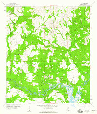 1959 Kiln1960 Print · USGSHancock County's coastal interior is captured here in the late fifties, showing the timberlands and bayous surrounding the settlement of Kiln. Genealogists can trace family landmarks like Catahoula Ch, Little Providence Ch, and the Bayou Coco Cem.4 unique versions available
End of results
Showing maps 1-6 of 6
Top cities near Diamondhead
- Long Beach historical maps
- Bay Saint Louis historical maps
- Waveland historical maps
- Pass Christian historical maps
Frequently asked questions
- What are the different types of historical maps available for Diamondhead?
- What is the oldest map of Diamondhead?
- Where can I purchase historical maps of Diamondhead for my home or office?
- Where can I download high-res historical maps of Diamondhead?
- Are there historical topographic maps available for Diamondhead?
- Is there historical aerial imagery available for Diamondhead?
- Where are historical maps of Diamondhead sourced from?