1970s Maps of Jackson, Mississippi
Explore 4 historic maps of Jackson from the 1970s. These maps offer a rare glimpse into what life looked like during the 1970s — showing old roads, neighborhoods, homes, and landmarks that have changed or disappeared over time.
Whether you're researching your family's past, planning a metal detecting trip, or studying how Jackson's landscape evolved across the 1970s, these high-resolution maps are a powerful tool for exploring the history of this region.
- Focus on a specific era: All maps on this page are from the 1970s, giving you a focused view of this time period.
- See what’s changed: Compare century-old streets, trails, and buildings to today's modern landscape using overlays and satellite layers.
- Research with precision: Use these maps for genealogy, historical research, land use analysis, or educational projects.
- View, download, or print: Maps are fully viewable online in high resolution, and can be downloaded or printed for your own records.
Start exploring Jackson's history through authentic maps from the 1970s. This is your window into the past.
Jackson, MS maps
(4)- 1971 Map of Florence, 1973 Print
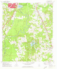 1971 Florence1973 Print · USGSThe Pearl River valley in the early seventies shows the growing connection between Jackson and rural Rankin County. Researchers can trace family history through sites like Smith Cem, Hickory Ridge Ch, and the old crossroads at Frenchs Store.
 - 1971 Map of Clinton, 1973 Print
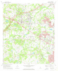 1971 Clinton1973 Print · USGSHinds County is captured in the early seventies as the suburban reach of Jackson begins to meet the historic grounds of Clinton. Genealogists and local historians can trace family sites at Cowles Meade Cem and Summer Hill Sch & Ch.
 - 1971 Map of Pocahontas, 1973 Print
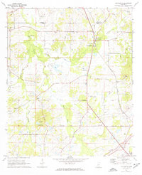 1971 Pocahontas1973 Print · USGSNorth of Jackson in the early seventies, this rural landscape reveals a community built around ancient earthworks and the railroad. Researchers can trace family sites like Tinnin Cem and numerous country churches including Society Ridge Ch and Wills Chapel.
 - 1971 Map of New Byram, 1973 Print
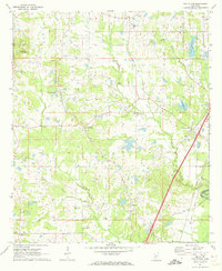 1971 New Byram1973 Print · USGSHinds County during the early 1970s shows a landscape of small crossroads and river bends south of Jackson. Genealogists can trace family connections through local landmarks like Spring Ridge Cem and country churches including Mt Salem Ch and Bethesda Ch.
End of results
Showing maps 1-4 of 4
Top cities near Jackson
- Clinton historical maps
- Madison historical maps
- Pearl historical maps
- Brandon historical maps
- Ridgeland historical maps
- Byram historical maps
See more
Top neighborhoods of Jackson
- Rolling Meadows historical maps
- North Town Plaza historical maps
- Northpointe historical maps
- Hope Springs historical maps
- Lakeover historical maps
- North Colony historical maps
See more
Frequently asked questions
- What are the different types of historical maps available for Jackson?
- What is the oldest map of Jackson?
- Where can I purchase historical maps of Jackson for my home or office?
- Where can I download high-res historical maps of Jackson?
- Are there historical topographic maps available for Jackson?
- Is there historical aerial imagery available for Jackson?
- Where are historical maps of Jackson sourced from?