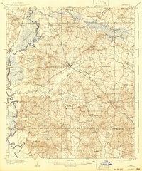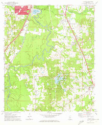
1971 Map of Florence
USGS Topo · Published 1973About this map
The Pearl River forms a winding natural boundary between Hinds and Rankin counties, dominating the center of this early 1970s landscape. Along its banks, the terrain is marked by significant hydrological features like Richmond Lake and the complex system of Hoover Lakes near Cleary. The industrial footprint of the era is evident in the numerous Gravel Pits concentrated near Taylorsville and along the Illinois Central Gulf rail lines, which facilitated the region's transport economy. To the north, the urban expansion of Jackson begins to press south, evidenced by residential developments like the Trailer Park and Lakeland. Rural life remains anchored by established landmarks such as Ebenezer Ch and Smith Cem, while the inclusion of Frenchs Store highlights the persistence of traditional local commerce nodes in the countryside.
Find a feature on this map
46 named features on this map. Tap any name to fly to it.
Don’t see what you’re looking for? This feature index may not catch every label — zoom into the map to look around manually.
Map Details
Editions of this 1971 Florence Map
This is the sole edition of this map. No revisions or reprints were ever made.
Historical Maps of Jackson Through Time
9 maps found