Old Maps of Issaquena County, Mississippi for Hiking & Exploration
Hike through history with 169 historic maps of Issaquena County. Explore old trails, ghost towns, and forgotten backroads — perfect for outdoor adventurers and local explorers.
- Rediscover forgotten places: Map out old mining camps, roads, and footpaths that no longer exist on modern maps.
- Layer with modern tools: Combine with LiDAR or satellite views to plan hikes through historical terrain.
- Made for exploration: Popular among hikers, overlanders, and local history lovers.
Use these maps to find adventure and explore the hidden past of Issaquena County.
Issaquena County, MS maps
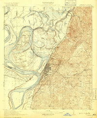
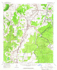
(169)- 1909 Map of Lake Providence
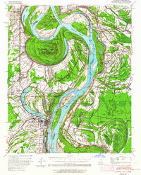
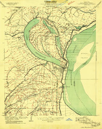 1909 Lake Providence1909 Print · USGSEast Carroll Parish at the turn of the century shows a landscape of expansive plantations and river commerce centered on the great oxbow. Genealogists and historians can locate family estates like Way Way Plantation or trace community roots at Good Hope Church and Watersheta School.2 unique versions available
 - 1909 Map of Wilsons Point
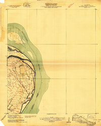 1909 Wilsons Point1909 Print · USGSEast Carroll Parish at the height of the river trade era reveals a landscape of alluvial points and levee-protected settlements. Genealogists and researchers can trace land tracts near Wilsons Point, the Morning Star Church, and the riverfront at Cottonwood.2 unique versions available
 - 1909 Map of Millikin
 1909 Millikin1909 Print · USGSEast Carroll Parish at the turn of the century reveals a landscape of large riverside estates and early rail infrastructure. Researchers can trace family history through sites like Ashton Plantation, find old commercial hubs like the Bells of the Bend Store, or locate vanished landmarks like Millikin School.2 unique versions available
 - 1911 Map of Lake Providence
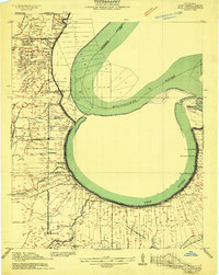
 1911 Lake Providence1911 Print · USGSLouisiana's Mississippi River delta region comes into sharp focus during the early 1910s, centered on the strategic oxbow lake at the parish seat. Genealogists and historians can trace family landholdings at Belle Mead Plantation or locate local landmarks like Winterfield School and Cane Ridge Church.2 unique versions available
 - 1913 Map of Wilson Point
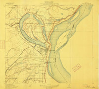
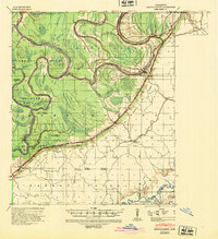
 1913 Wilson Point1913 Print · USGSEast Carroll Parish at the height of the levee-building era shows a landscape defined by the shifting banks of the Mississippi River. Researchers can trace the riverfront settlements at Wilson Point and Cottonwood, or locate the Morning Star Church near the water.
 - 1918 Map of Vicksburg
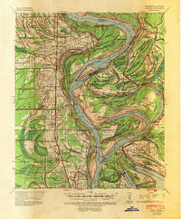
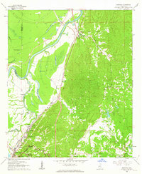
 1918 Vicksburg1918 Print · USGSVicksburg and the Mississippi River bluffs are shown in great detail during the early twentieth century. Researchers can locate Civil War landmarks like Grants Canal and Vicksburg National Military Park or trace family roots near Blakeley and Cedars.4 unique versions available
 - 1939 Map of Onward
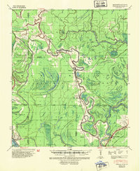 1939 Onward1939 Print · USGSThe Mississippi Delta in the late 1930s shows a landscape of river-bend settlements and bayou-side commerce before modern infrastructure took hold. You can trace the Illinois Central railroad through Smedes and Kelso or locate family landmarks like Haynes Bluff and the Lumber Yard at Valley Park.3 unique versions available
 - 1939 Map of Lorenzen, 1941 Print
 1939 Lorenzen1941 Print · USGSSharkey County at the end of the Depression era is a intricate landscape of rail junctions and Delta waterways. Genealogists and researchers can trace local landmarks like Mont Helena, the Indian Mound at Grace, and rural stations such as Riverside Jct and Lorenzen.2 unique versions available
 - 1939 Map of Readland, 1942 Print
 1939 Readland1942 Print · USGSThe tri-state delta country comes alive in this late Depression-era survey of the Mississippi riverfront. Genealogists and historians can trace numerous rural congregations and landings, from the Graymound Cem to Lakeport Ldg and Daniels Chapel Shiloh Ch.3 unique versions available
 - 1939 Map of Alsatia, 1953 Print
 1939 Alsatia1953 Print · USGSThe river-driven landscape of the Louisiana and Mississippi border is shown here during a period of massive hydraulic engineering. Researchers can trace the shifting river channel and rail-stop settlements like Alsatia, Fitler PO, and Sondheimer.2 unique versions available
 - 1939 Map of Mayersville, 1964 Print
 1939 Mayersville1964 Print · USGSThe Mississippi River meanders between Louisiana and Mississippi in the late 1930s, showing a landscape defined by dramatic cut-offs and levee engineering. Genealogists and researchers can locate landmarks like Rose Hall, the Indian Mound, and rural congregations at Mt Olive Ch.
 - 1939 Map of Swan Lake, 1966 Print
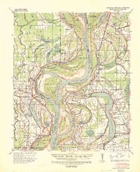
 1939 Swan Lake1966 Print · USGSThe Mississippi Delta's intricate water and rail networks are captured here during the late 1930s. Researchers can locate numerous plantation-era settlements and landmarks including Indian Mounds, the community of Nitta Yuma, and the grounds of Leroy Percy State Park.
 - 1940 Map of Mechanicsburg, 1947 Print
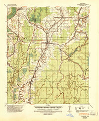
 1940 Mechanicsburg1947 Print · USGSThe Yazoo River Delta in the early 1940s reveals a landscape defined by steamboat landings and the edge of the Loess Bluffs. Researchers can trace historic river access points like Enola Ldg and Miller Ldg or locate the early footprints of Satartia and Mechanicsburg.2 unique versions available
 - 1941 Map of Vicksburg, 1946 Print
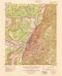 1941 Vicksburg1946 Print · USGSVicksburg and its riverfront were entering the war years when this survey was updated, documenting a landscape of strategic waterway engineering. Genealogists can trace family roots at Redwood, Beechwood, or Culkin Academy and locate the National Cem.3 unique versions available
 - 1953 Map of Greenwood, 1966 Print
 1953 Greenwood1966 Print · USGSThe Mississippi Delta in the mid-fifties is captured here as a thriving network of river towns, railroads, and oxbow lakes. Researchers can trace the legacy of the Illinois Central Railroad and locate landmarks like the State Penal Farm and Greenville Air Force Base.5 unique versions available
 - 1955 Map of Jackson
 1955 Jackson1955 Print · USGSThe Lower Mississippi Valley at the middle of the century reveals a landscape of deep river meanders and growing rail hubs. Genealogists and historians can trace the mid-century footprints of Vicksburg National Military Park, old river landings at Port Gibson, and the rail corridors of the Illinois Central Railroad.3 unique versions available
 - 1956 Map of Greenwood
 1956 Greenwood1956 Print · USGSThe Mississippi Delta in the mid-fifties is captured here during a period of significant military and agricultural activity. Researchers can trace the rail lines of the Illinois Central RR, find the Greenville Air Force Base, or locate the State Penal Farm.
 - 1961 Map of Jackson
 1961 Jackson1961 Print · USGSThe Lower Mississippi Delta and the state capital area are captured here during the post-war era of infrastructure expansion. Researchers can trace the complex river oxbows and rail lines connecting Vicksburg, Yazoo City, and the Illinois Central Railroad network.
 - 1962 Map of Jackson
 1962 Jackson1962 Print · USGSThe Mississippi Delta and the state capital region are mapped here in the early sixties, showing a landscape defined by the great river and the growing city of JACKSON. Genealogists can trace family roots through numerous landmarks like Cedar Hill Cem, rural stops on the Illinois Central RR, and historic sites like Champion Hill.2 unique versions available
 - 1962 Map of Redwood, 1963 Print
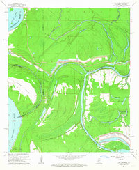
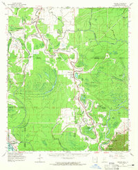
 1962 Redwood1963 Print · USGSWarren County at the start of the 1960s shows a landscape of river-bottom commerce and Civil War history. Genealogists and historians can trace the Old Indian Treaty Boundary or locate St James Ch and the Site of Fort St Peter.3 unique versions available
 - 1962 Map of Long Lake, 1963 Print
 1962 Long Lake1963 Print · USGSThe riverlands of Warren County were undergoing a major industrial transformation in the early sixties. Genealogists and historians can trace the development of the Vicksburg Industrial Harbor and locate local landmarks like Pilgrims Rest Ch and Browns Point.3 unique versions available
 - 1963 Map of Mechanicsburg, 1965 Print
 1963 Mechanicsburg1965 Print · USGSThe Yazoo Delta and its surrounding bluffs are shown in the early sixties as a landscape of river landings and rural parishes. Researchers can trace family history through Satartia, Mechanicsburg, and numerous rural churches like Germania El Bethel Ch or Lynch Chapel.
 - 1963 Map of Onward, 1965 Print
 1963 Onward1965 Print · USGSThe Mississippi Delta lowlands appear in detail in the early sixties, showing the rail-and-river network before modern land-use changes. Genealogists can trace family names through rural landmarks like Rock of Mt Zion Ch, Valley Park, and the Cement Plant at Haynes Bluff.3 unique versions available
 - 1964 Map of Vicksburg
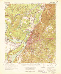 1964 Vicksburg1964 Print · USGSVicksburg and the Mississippi River loops are shown here in the mid-1960s, capturing a landscape defined by historic channel shifts and flood control efforts. Genealogists can trace family roots through numerous local landmarks like Culkin Academy, Redwood, and Mt Shiloh Ch.2 unique versions available
 - 1964 Map of Lorenzen, 1966 Print
 1964 Lorenzen1966 Print · USGSThe Mississippi Delta's intricate bayou network is meticulously detailed here during the mid-1960s. Genealogists and local historians can trace family roots through numerous landmarks like St Michaels Ch, Elmwood Cem, and the old rail stop at Riverside Junction.2 unique versions available
Showing maps 1-25 of 169
Top cities of Issaquena County
Frequently asked questions
- What are the different types of historical maps available for Issaquena County?
- What is the oldest map of Issaquena County?
- Where can I purchase historical maps of Issaquena County for my home or office?
- Where can I download high-res historical maps of Issaquena County?
- Are there historical topographic maps available for Issaquena County?
- Is there historical aerial imagery available for Issaquena County?
- Where are historical maps of Issaquena County sourced from?