1990s Maps of Issaquena County, Mississippi
Explore 9 historic maps of Issaquena County from the 1990s. These maps offer a rare glimpse into what life looked like during the 1990s — showing old roads, neighborhoods, homes, and landmarks that have changed or disappeared over time.
Whether you're researching your family's past, planning a metal detecting trip, or studying how Issaquena County's landscape evolved across the 1990s, these high-resolution maps are a powerful tool for exploring the history of this region.
- Focus on a specific era: All maps on this page are from the 1990s, giving you a focused view of this time period.
- See what’s changed: Compare century-old streets, trails, and buildings to today's modern landscape using overlays and satellite layers.
- Research with precision: Use these maps for genealogy, historical research, land use analysis, or educational projects.
- View, download, or print: Maps are fully viewable online in high resolution, and can be downloaded or printed for your own records.
Start exploring Issaquena County's history through authentic maps from the 1990s. This is your window into the past.
Issaquena County, MS maps
(9)- 1994 Map of Indianola
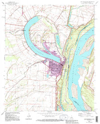
 1994 Indianola1994 Print · USGSThe Mississippi Delta's rich agricultural heartland is documented here in the mid-1990s, showing a landscape defined by meandering rivers and rail lines. Genealogists and historians can trace family roots in rural settlements like Nitta Yuma and Midnight or locate the sprawling Yazoo National Wildlife Refuge.
 - 1994 Map of Millikin, 1995 Print
 1994 Millikin1995 Print · USGSThe Louisiana-Mississippi borderlands appear here in the mid-1990s as a complex network of oxbow lakes and alluvial islands. Genealogists can locate family landmarks like Panola Cem, Jerusalem Ch, and the rural settlement at Gassoway.
 - 1994 Map of Lake Providence, 1995 Print
 1994 Lake Providence1995 Print · USGSLake Providence sits at a great Mississippi River oxbow in the mid-1990s, where the town grid meets the alluvial basin. Genealogists can trace family landmarks like Providence Memorial Park and historic congregations such as St Mary Ch.
 - 1994 Map of Transylvania, 1995 Print
 1994 Transylvania1995 Print · USGSEast Carroll Parish sits along a volatile stretch of the Mississippi River in the 1990s, where the landscape still bears the scars of historic floods. Researchers can trace land use through the Hollybrook Crevasse or locate family sites like Cold Tart Cem and the Morning Star Ch.
 - 1994 Map of Mayersville, 1995 Print
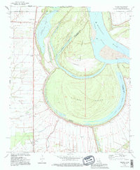
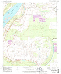
 1994 Mayersville1995 Print · USGSThe Mississippi River delta near the turn of the millennium reveals a complex landscape of shifting chutes and ancient earthworks. Genealogists and historians can trace local life at Mayersville through the New Bethel Cem Ch, Issaquena Sch, and the nearby Indian Mounds.
 - 1994 Map of Whiting Bayou, 1995 Print
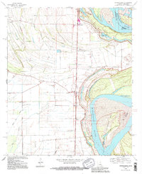
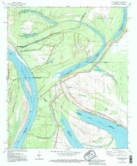
 1994 Whiting Bayou1995 Print · USGSThe Mississippi Delta's intricate riverfront and oxbow lakes are captured here during the mid-1990s as the river meanders past Stack Island. Genealogists and local historians can locate rural landmarks like Tallula, St James Ch, and the Old Railroad Grade.
 - 1994 Map of Eagle Bend, 1995 Print
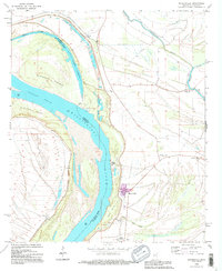
 1994 Eagle Bend1995 Print · USGSThe Mississippi River delta country near the Louisiana border comes alive in this mid-nineties update. Trace the river's path around Henderson Island and find local landmarks like Brunswick, Mt Zion Ch, and the Kiger Cem.
 - 1994 Map of Fitler, 1995 Print
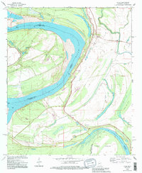 1994 Fitler1995 Print · USGSThe Mississippi Delta riverfront comes alive in the mid-nineties as the river snakes past Fitler. Researchers can trace the levee system and find local landmarks like Magna Vista, Pleasant Green Ch, and the oxbows of Albemarle Lake.
 - 1994 Map of Sondheimer, 1995 Print
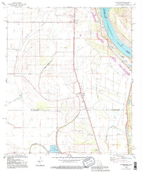 1994 Sondheimer1995 Print · USGSThe alluvial plains of East Carroll and Madison Parishes are captured in the 1990s as the river economy modernized. Genealogists can locate family landmarks like Henderson Sch, New Bethlehem Ch, and the settlement of Enoka.
End of results
Showing maps 1-9 of 9
Top cities of Issaquena County
Frequently asked questions
- What are the different types of historical maps available for Issaquena County?
- What is the oldest map of Issaquena County?
- Where can I purchase historical maps of Issaquena County for my home or office?
- Where can I download high-res historical maps of Issaquena County?
- Are there historical topographic maps available for Issaquena County?
- Is there historical aerial imagery available for Issaquena County?
- Where are historical maps of Issaquena County sourced from?