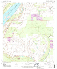
1994 Map of Whiting Bayou
USGS Topo · Published 1995About this map
The Mississippi River defines the western edge of this landscape, separating Issaquena County from East Carroll Parish along a complex boundary that weaves past Stack Island. The interior is dominated by the remnants of the river's shifting course, including oxbows and swampy depressions like Carlisle Lake, Bear Lake, and Goose Lake. Small rural communities and religious centers anchor the local geography, notably the settlement of Tallula and several churches including St James Ch, Woodland Ch, and St Peters Ch.
Find a feature on this map
22 named features on this map. Tap any name to fly to it.
Don’t see what you’re looking for? This feature index may not catch every label — zoom into the map to look around manually.
Map Details
Editions of this 1994 Whiting Bayou Map
This is the sole edition of this map. No revisions or reprints were ever made.
Other maps of this area

1909 · Lake Providence
USGS Topo · 1:24,000

1909 · Wilsons Point
USGS Topo · 1:24,000

1909 · Millikin
USGS Topo · 1:24,000

1911 · Lake Providence
USGS Topo · 1:31,680

1913 · Wilson Point
USGS Topo · 1:31,680

1939 · Onward
USGS Topo · 1:62,500

1939 · Lorenzen
USGS Topo · 1:62,500

1939 · Alsatia
USGS Topo · 1:62,500

1939 · Mayersville
USGS Topo · 1:62,500

1955 · Jackson
USGS Topo · 1:250,000