
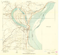
1909 Map of Lake Providence
USGS Topo · Published 1909About this map
Lake Providence and its distinctive oxbow dominate this Mississippi River landscape at the beginning of the twentieth century. The map illustrates a highly developed riverine economy where large estates like Belle Mead Plantation, Olivedell Plantation, and Desona Plantation line the fertile alluvial plains. The town of Lake Providence serves as the central hub, situated where The Chute meets the main Mississippi River channel near Stack Island.
Find a feature on this map
37 named features on this map. Tap any name to fly to it.
Don’t see what you’re looking for? This feature index may not catch every label — zoom into the map to look around manually.
Map Details
Editions of this 1909 Lake Providence Map
2 editions found
Other maps of this area

1909 · Baxter Bayou
USGS Topo · 1:24,000

1909 · Wilsons Point
USGS Topo · 1:24,000

1909 · Millikin
USGS Topo · 1:24,000

1909 · Ashton Bridge
USGS Topo · 1:24,000

1911 · Lake Providence
USGS Topo · 1:31,680

1911 · Baxter Bayou
USGS Topo · 1:24,000

1912 · Ashton Bridge
USGS Topo · 1:31,680

1913 · Wilson Point
USGS Topo · 1:31,680

1914 · Baxter Bayou
USGS Topo · 1:31,680

1935 · Oak Grove
USGS Topo · 1:62,500